Beauty, the quality of being physically attractive is something that the user will encounter after they downloads this app. My co-workers and I, Ayano Morishima are making an route simulator known as “Road to Beauty” that takes the user to a journey that can lead them to a beautiful constructed location. Many people uses other apps to locate their shortest and fastest route, so that they could get to their location much faster. Taking a different walk from your usual course of route would open your view on beauty after downloading this app, which it contains features of short, fast and beautiful route.
Many apps from the apple store contains route simulator that pinpoints to the users location and calculate time to show them different option in best or shortest route to get there quickly as possible. However, is it time that the users want to save up to get to their destination? Sure, people want to get there quickly and do whatever they needed to do. But what if there is an app that can change the users surrounding views? Think about it, looking at the same route over and over is boring. The user might already know whats built there, even if they are blind! Our app focuses on people’s daily route and time, however what is different is users can use this app to encounter a beautiful constructed location just by taking a different route. Simple right? By changing just a little routine of using the same route to their destination; even if it takes just an extra few minutes, sure the surroundings of the users view will changes. Peter Terzian states that “The Heights wears its rich history on its sleeve, with the area a showcase of stately architectural styles, august churches and schools and literary landmarks.” Basically, the author is saying that there is a lot to see at the Brooklyn Heights. Such as churches, beautiful architecture, school, etc. Its beauty captivates people hearts and its amazing location with in Brooklyn heights conveys the inner beauty in Brooklyn.
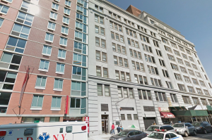
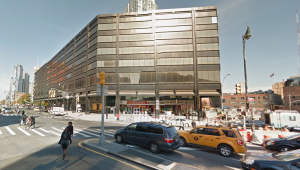
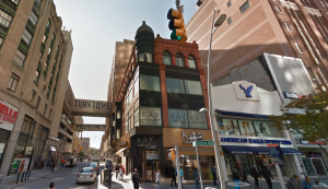
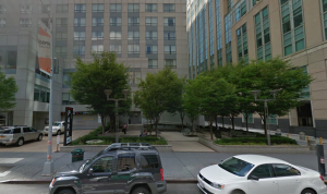
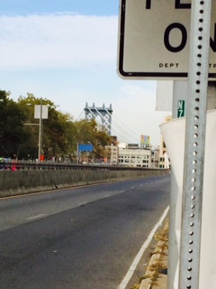
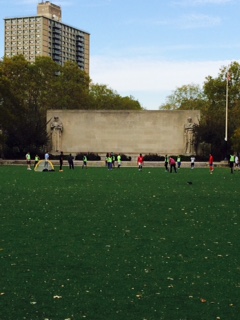
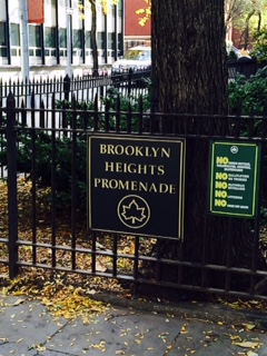
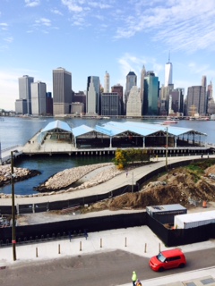
One of the ongoing project route starts from the Voorhees building. This building is a center for engineering technology for students who does to NYC College of Technology. Once you left the building to make a right, you will see a big road. If you turn right again, you would encounter an entrance of Brooklyn Bridge. Brooklyn Bridges connects the two boroughs, Manhattan and Brooklyn crossing over the East River. As you go further straight, you will see a huge park called, Cadman Plaza Park. A huge park where you can play any sports. Walk to right and left again, where you will encounter location called, Brooklyn Heights Promenade. As you go in though this location, and keep walking straight, you will see a Brooklyn Bridge Park Pier 2. Place where it features in basketball, handball, etc. Each locations shows the beauty of each aspect in how it was constructed for. For example, since the Voorhees building was built unique, which it intrigues people who are interested in architecture or simply how different they are. Also, Brooklyn Bridge Park Pier 2’s building is constructed beautiful, because of the surrounded body of Hudson river and the view of the sky scrapers of Manhattan. Ronda Kaysen states that “As it is, many preservationists worry that Midtown could soon reach a tipping point in which the architectural mix of old and new is lost to a wash of sparkly glass.” Basically, the author is saying that not only in Manhattan, but other boroughs such as Brooklyn architecture are in need to keep an eye out. Soon or later it would be demolished without knowing.
These exampled location is a place where the users will encounter in the app. Such as the caption below will pop up to explain a little information that the user could do, when they arrive at certain locations. Many volunteers contributed to this route making, so that it shows the best time to go to the location, where it also shows the “best time” to go to the location at the top right corner. An example for the location above is, “the best time to go to the location” is between 2:30pm to 5:30pm. One of the volunteer commented, “It is a great place to go, especially since it is quite. You can see how each location are constructed differently comparing it to other locations. Going with friends or family would be a great way to explore a new route!” Thanks to our volunteers, this app does contain other features, such as little game that satisfies the users traveling, voice active system where you use it like Siri, time countdown where it countdowns time to get to the location. The article of The Adventure of a New Perspective: A Literary Walk in Brooklyn Heights states that, “Brooklyn Heights still retains a sense of dignity and quiet, the legacy of a residential neighborhood that was famous in the nineteenth century for its churches and for its elegant homes built by merchants and sea captains in the shipping trades.” Basically, the article is saying that Brooklyn Heights is the best place to go and explore about the legacy of a residential neighborhood and the beautiful scenery that smooths people heart.
Seeing different surroundings would motivate users to look though into new route to their destination, where they haven’t discovered yet. By using this app Road to Beauty, not only they gives the best option in shortest route, but to think about the user’s preference in showing beauty of how the location was constructed. Many people looks for quick way to get to the destination that they are seeking. However what if there is a route that is short and beautiful enough to make you use this app again? Why won’t you not give it a try?
Work Cited List:
Terzian, Peter. must-see Brooklyn Heights March 03, 2014. Web. November 16, 2015.
Kaysen, Ronda. “Midtown’s Vanishing Historic Architecture” New York Times. June 5, 2015. Web. November 16, 2015.
No name. “The Advantages of a New Perspective: A Literary Walk in Brooklyn Heights” Blog: Walking Of The Big Apple. October 12, 2010. Web. November 16, 2015.
Rosen, Jody. “Write about resources” OpenLab. Web. November 6, 2015.