Leave a reply
Library/Archive Report 2
ARCHIVE REPORT #1 Brooklyn Public Library
Introduction
The Brooklyn Public Library has thousands of public programs, extensive book collections,and digitized newspaper articles. They have an online database to look up articles for research material. We will visit the Brooklyn Collection to Research downtown Brooklyn area. We will have access to archival material such as maps and historic Brooklyn photographs. My goal is to find two Sources in a time frame of interest, which will be between 1770’s and 1820’s.
Library/Archive Report 1
Site report 2
HW # 6
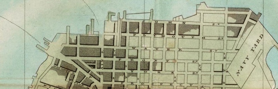
I discovered during 1776- 1820 in Vinegar Hill there was not much technology available in the community. During those time people found it difficult to create and construct new projects for the community such as buildings, schools, and parks. There were no resources or equipment available to store or save materials and documents such as blueprint of buildings and important government documents. It was very hard to capture things because people did not have the proper writing materials and resources to grasp the view and different scenario that was happening during that time. However, I found out what people did to compensate for their lack of resources was drew on maps in specific areas to store important information. These maps were very few and limited because they did not have the technology to duplicate them.
The information we were unable to capture was the farm plot shown on the old maps. We will be able to access these documents by visiting the library archives and requesting the specific documents or though the internet where it is more easy and convenient. Other information that was not available to view was the State Documents that show the development of Urban Renewal and the people who started it. I believe the reason these document were not available is because they got damage or destroyed over a period of time, making it difficult to keep together and display in the library archives or posted on the internet.
Reflection #7: GIS: Old Principles with New Capabilities
When reading the handout on geographic information system, I found that the section discussing the use of GIS during urban planning to be very interesting. GIS is an essential tool in sustainable development. This is especially true in urban areas where there is a steady increase in population. I think the practicality of GIS technology is vast and will continue to evolve as other forms of technology change. I like that there is a lot of positivity that comes from using GIS during urban planning. It allows developers to use empirical data to determine a healthy, optimum area to create cities. Because of this, the people who will move into these cities will have the opportunity to experience a higher quality of life as opposed to cities built on any type of land.
Vinegar Hill Site Report 2
GIS as a tool for research
Geographical Informational System (GIS) as a tool for research is now an integral part for many institutions for analyzing and planning architecture, infrastructure, facilities, etc. especially for ensuring conformity to established policies and regulation; however, the GIS technologies available today are still not advanced enough to forecast accurately. The potential for improvements in planning and development of human and environmental interests are still adequate enough to continue to use and improve GIS capabilities and qualities. Also, enabling more user friendly apps will help to permit data to be more efficiently, effectively, and appropriately acquired and discriminated, so not only less than expert GIS users can have access and implementation to this incredible technological resource. The only major concerns now are in the ways that this publically accessible information will be used. Also, there needs to be a cost effective means for verification and confirmation of the accuracy, legitimacy, proper and ethical uses, etc. of the open source GIS technologies. GIS technologies may help in many ways but there are still more complexities and concerns involved/inherent within the use and improvement of GIS technologies. The work load still doesn’t become reduced, but the gain in quality of life and of the environment is priceless. GIS technology is worth the investment of reasonable resources, it is economically and environmentally profitable, and it is worth every effort thus far…

