Author Archives: CarlosM

Final Project Brooklyn 1827

Link to shared files:  https://github.com/coderhub/Brooklyn_1827

Created By: Carlos Merced
Date: May 25, 2016
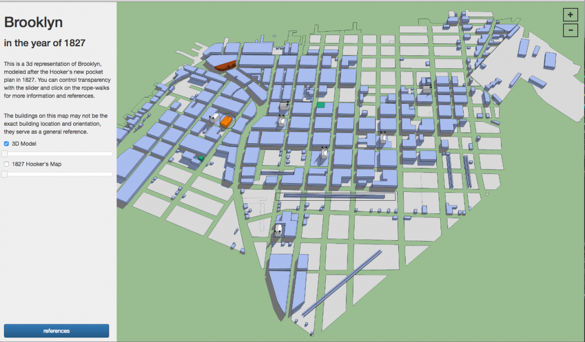
Title: Brooklyn in the year of 1827

** Works in Firefox and Google Chrome updated browsers **

This 3d model of Brooklyn shows the land occupied or sold in 1827, along with rope walks and other building data. The blue represents occupied space and the tan color represents undeveloped or unsold land plots.

Click on index.html to view the interactive map.      Screen Shot 2016-05-25 at 6.47.18 PMScreen Shot 2016-05-25 at 6.47.34 PM

Brooklyn Historical Society

The Brooklyn Historical Society has a special collections and archives library on the second floor. It is located in Brooklyn at the corner of Pierrepont Street and Clinton Street. The collection materials are related to Brooklyn’s history and culture, which contains oral interviews, photographs, maps, books, paintings and more. I will focus on any material related to John Jackson and early maps of Brooklyn.

BHSArchiveReport

Midterm: The Changing Landscape of Vinegar Hill

MidternChangingLandscape

The American Revolution Started in 1775 and lasted up until 1783, when a peace treaty with the British was signed. At this time the United States were establishing themselves as an independent power and doing away with British customs. The United Stated seized land from many people who sided with the British, leading to an opportunity for the Sands brothers.Vinegar Hill has a rich history and has gone through many changes over the years. What is now known as Vinegar Hill today, is situated from Front street to the waterfront and from Bridge street to the Brooklyn Navy Yard. Vinegar Hill has experienced the most change in between the time periods of 1780 and 1830, transitioning from farmland to a grid plan. Vinegar Hill and surrounding areas like Dumbo and the Brooklyn Navy Yard, have experienced heavy waterfront development.This leads to questions critical to Vinegar Hills’ development. Where is the natural waterline located, in comparison to today? What maps existed in between these time periods  and what was their purpose? What are rope walks? Why did the U.S. Navy choose Wallabout Bay?

LIBRARY / ARCHIVE REPORT #3

LibraryArchiveReport3

The LaGuardia and Wagner Archives was constructed to preserve primary material documenting the social and political history of New York City. It is located at Fiorello H. LaGuardia Community College and holds papers and microfilm of Robert Wagner, Edward Koch, the New York City Housing Authority and More. Our focus will mostly be the housing documents of Brooklyn specifically the NYCHA Photograph Collection. We will be looking at the Urban renewal of Vinegar Hill and different housing structures in Brooklyn.

New York Public Library ARCHIVE REPORT #2

LPLibraryArchiveReport2

The New York Public Library was founded in 1895 and is the nation’s largest public library system. The one we will be visiting is the Stephen A. Schwarzman Building in Midtown manhattan. They have a large variety of special collections material, but we will focus on maps in the brooklyn area. The maps being viewed will range as early as 1776, to late 1980’s. I would like to find at least two primary sources that related to an early time period of Brooklyn.

ARCHIVE REPORT #1 Brooklyn Public Library

LearningPlacesArchiveReport1

Introduction

The Brooklyn Public Library has thousands of public programs, extensive book collections,and  digitized newspaper articles. They have an online database to look up articles for research material. We will visit the Brooklyn Collection to Research downtown Brooklyn area. We will have access to archival material such as maps and historic Brooklyn photographs. My goal is to find two Sources in a time frame of interest, which will be between 1770’s and 1820’s.

Archival Material Post # 5

The Robert Moses Papers are arranged into sixteen principal series. These series are based on the projects he was involved in and within each series it is ordered by different time periods. Some of the archival material that can be found are speeches, memoranda, press releases, reports, plans, photographs, and more relating to Robert Moses. The material types available are Blueprints, maps, and photoprints. I didn’t think that blue prints were available to the public, free to view. I always had the impression that these documents were reserved for architects or city planners. In order to access the material you should first visit the facility website and fill out a request access form for the Robert Moses papers, which require your name, email, and address.