Tag Archives: Vinegar Hill

Hypothesizing Vinegar Hill 1800-1840

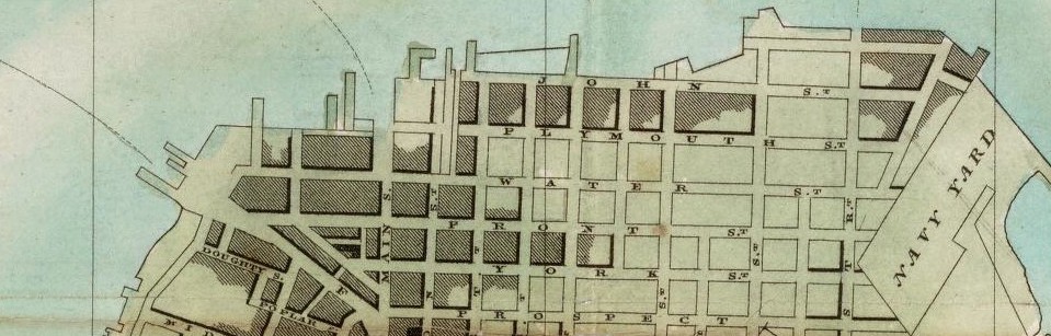
When Vinegar hill moved into the nineteenth century, people like Joshua Sands , a speculator and merchant, bought up land and started creating businesses. He imported machines from England and he also brought workers from there. Joshua Sands opened the rope walk industry on the waterfront. In 1801 the U.S. Navy Yard opened their first yard by Wallabout Bay, which became very active in the war of 1812. The first steam ferry came in on 1814 and was traveling from Vinegar Hill to Manhattan and that lasted for a long time, even though they had contradictions here and there. The Village of Brooklyn turned into the Town of Brooklyn in 1816 and it had grown in terms of housing and people. In 1827 different versions of the Hooker’s map came out. Brooklyn had a considerable growth of population during 1830-1840 when the lower Manhattan by the ferry stop became mostly commercial, so people were considering the other stop of the ferry in Vinegar Hill as a short commute. In 1834 Brooklyn changed its status again from Town of Brooklyn to the City of Brooklyn.

Final Project Deliverable

After couple of site and library visits we got in contact with lots of information and archives. My attention was captured by the Hooker’s New Pocket Plan of the Village of Brooklyn from 1827. Since then I decide to base my project in that map and analyse it. The map on the side has written the the most important public places and their approximate location since they didn’t have numbers for the houses to have and exact location. I will deliver a tree dimensional view of the massing on the whole map and the grid of it. Also, since the information on the map is placed separately based on their functionality, I will label and color-code these functionalities so they can be spotted right away from the map. I also will try to give them a shape based on some drawings of places that I found in our library visits. From that era we have only drawings since the camera didn’t exist yet. There are six rope walks in this map as well that aren’t part of the information given on the side of the map. So I will be focusing a part of my research on rope walks, and also a writing general information about them.

Vinegar Hill Site Report 3

Vinegar Hill Site Report 3 – Aisel Omerbashi

LaGuardia Community College Wagner’s Achieve

LaGuardia Community College Wagner’s Achieve – Aisel Omerbashi

Brooklyn Public Library

Brooklyn Public Library Report – Aisel Omerbashi

New York Public Library Report

New York Public Library – Aisel_Omerbashi

Brooklyn Historical Society

Brooklyn Historical Society Library Report_Aisel Omerbashi

Learning Places – Final Project

LIB 2205 ARCH 2205_SP16_ALMEIDA-MONTGOMERY_AISEL-OMERBASHI_FINAL

Project Plan

Deliverables: I will be constructing a report/summary (Presentation Material) of the information from my research of the demographics, politics, and urban renewal of the 1920s thru the 1960s (Scope), which may be presented as a PowerPoint/Prezi Presentation, and/or documentation report, and/or project, and/or technological media on a consolidated platform such as OpenLab, CartoDb, SketchUp, Wikipedia, YouTube, etc. I will be able to determine the most appropriate platform once my project is in the final stages. I will also coordinate my research with a classmate since we are focusing on similar aspects of my research project. His consolidation platform would be my main consideration towards my research contribution.

Report/Summary Construction Process: I will be using and consolidating the information from the resources from my research, such as libraries (books), web searches (“dot-gov” and articles), archives (historical maps/documents). The main consolidation of information will be taken from my previous reports and bibliography. I will combine and focus information regarding demographics, politics, and urban renewal to produce a final project geared towards a sociological (social sciences) approach.

Research Gaps: Although there is information regarding the demographics, politics, and urban renewal of the 1920s thru the 1960s, there has been limited information about the causes for the landscape cutoff point at Hudson Avenue and York Street.

Evolution of My Project: My project has changed/morphed from a focus of the cause of a physical aspect (landscape) of a street (Hudson Avenue) into a more sociological focus of the demographics and politics involved in the urban renewal of the 1920s thru the 1960s.