End of the semester reflection

1. After taking this course, research seems much more tangible and much more enticing. I feel much more confident in finding sources, annotating them and utilizing them for a subject of interest. I was also satisfied with the numerous fields we have taken, some of which I never knew existed (the NYCHA archives at LaGuardia CC).

2.  As a design student, the idea of a geographic viewpoint has always been relevant. The specificity of geographic viewpoint, site, or location is a great enabler for students, as it may inspire them to further investigate why conditions were the way they were, why conditions have changed as well as the possible projection or invention of what could be made next. However, from a interdisciplinary standpoint, it is imperative to recognize the different methodologies used to extrapolate information.

3. I will most certainly use or seek out more primary sources in the future, as they are incredibly relevant to architecture, urban design and planning. Primary sources are often a critical ingredient for proper research, analysis and sometimes design proposals.

4. Research can be more engaging if the subject of interest is discovered earlier, and if the tools used to facilitate the research are well understood by students and are further demonstrated (i.e sketchup)

Final Course Reflection

  1. How do you view search differently?

Well i will say this was totally new research experience for me, as an engineering major i never really did research like this, which mostly base on history, libraries and archives.  All tools we used in this class as a search engine were really interesting for example Brooklyn Eagle newspaper which i can access from any public library, secondly GIS was really impressive as well.

2. How does a geographic viewpoint impact you after this course?

Just like i said before i never had this kind of class before, i think its because i always take my engineering courses but this time i wanted to try a different course but also have some relation with my major as well. After visiting the sites in vinegar hill and learning about all the history of  that area i felt i was missing lot of stuff in my life. It was really interesting to see how old architecture developed with time.

3. Will you use primary source in future? Why?

In my case yes of course i will because i am doing civil engineering so and as a member of American Society of Civil Engineer i know we have to deal with lot of publications in data center, so i will see primary sources more often.

4. How could teachers make research a more engaging process? What could be taught earlier?

I think its better to introduce all the tools for research at the beginning  of semester in that way everyone will have little extra experience at the end of the semester, which will help all students to produce a well developed project.

Final Reflection

1. How do you view research differently?

Over the semester, I have learned a few new research methods. Coming from a liberal arts background, I was already exposed to library resources, especially online databases. Some new resources, especially NYC public resources, were new for me, and they were very illuminating. The research tools, especially GIS tools, were especially interesting; they have opened up a whole new way for me to interact with spatial data.
2.  How does a geographic viewpoint impact you after this course?
Well, I had never studied a “place” before, so it was a new experience doing so. I will always stop and think now about a location’s history wherever I go. I am tempted to look at some archival information in my home town of White Plains now.
3. Will you use primary sources in the future? Why?
Possibly. I am heading into medical research at the moment, and I guess case reports are a primary source. Medical photography could be considered primary source as well, though I’m not sure the term applies outside of a historical context.
4.  How could teachers make research a more engaging process? What could be taught earlier?
I think a scavenger hunt experience, in the archives could be an interesting exercise, especially early on. I would like to have seen GIS tools earlier.  A multi-class Sketchup demo would be good too, as it is a very useful tool.

End of Semester Reflection

  1. Prior to this class, research in general has always been the most daunting part of assigned projects and papers. By researching so frequently during the course of the semester, it is a task that I am much more used to. I now know about more research tools and databases, which will come in handy for any future research projects that I may have. In addition, visiting archives and libraries to do research is something that I have not done often prior to this course. It was a good experience for me to be able to visit a site and actually look through tangible sources rather than just depending on computer-based research.
  2. I think that having a geographic viewpoint in mind when researching helps narrow down one’s scope. By knowing that the area we were focusing on was Vinegar Hill, I was sure to focus my research on that neighborhood and surrounding neighborhoods. As a class we visited sites that either were located in Brooklyn or had sources about Brooklyn. The sources acquired at these sites were much more relevant.
  3. I will definitely be seeking out primary sources in the future. These sources will most likely not be maps, photographs, or bridge plans. Due to my field of study, which is legal studies, legal research plays a large role in working efficiently and drafting documents. Cases and statutes will be primary sources that I will need to research and cite to both in my classes and work.
  4. I think that because many people do not have much experience doing primary source research, being provided with online databases and knowing how to contact libaries and archives for help would make research more engaging. Once a person gets confident in researching sources, he or she will be more inclined to do so. When research is place-based, it would be beneficial to the researcher to visit the location. I think being able to have firsthand experiences and observations of an area would help with engagement.


Final Report: Brooklyn Maps Overlay

To edit code, use visual studio 2010 or newer.  Original images are available inside an Adobe PS psd file.

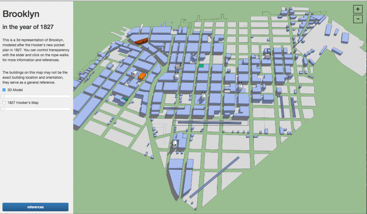
This tool lets you overlay maps of Brooklyn, and vary the transparency.

GitHub repo for the project!

Download Project Executable!  (Windows)

Sources:

Lionel Pincus and Princess Firyal Map Division, The New York Public Library. (1878). Colton’s New York City : Brooklyn, Jersey City, Hoboken, etc. Retrieved from http://digitalcollections.nypl.org/items/75058670-f3a2-0130-4cc1-58d385a7b928

Lionel Pincus and Princess Firyal Map Division, The New York Public Library. (19–?). Map showing proposed extension of Flatbush Avenue to Brooklyn Bridge. Retrieved from http://digitalcollections.nypl.org/items/340c4540-d350-012f-2c90-58d385a7b928

Lionel Pincus and Princess Firyal Map Division, The New York Public Library. (1919). Brooklyn – Liberty Loan Committee – division of districts. Retrieved from http://digitalcollections.nypl.org/items/20d2f230-d2ac-012f-3549-58d385a7bbd0

Lionel Pincus and Princess Firyal Map Division, The New York Public Library. (1906). Brooklyn and vicinity. Retrieved from http://digitalcollections.nypl.org/items/9defba10-d299-012f-0a03-58d385a7bbd0

Lionel Pincus and Princess Firyal Map Division, The New York Public Library. (1907). Map of the Borough of Brooklyn, City oh New York. Showing street pavements other than cobble stone on January first, 1907. Retrieved from http://digitalcollections.nypl.org/items/ad8f6ba0-d296-012f-6380-58d385a7bbd0

Lionel Pincus and Princess Firyal Map Division, The New York Public Library. Brooklyn land use policy Retrieved from http://digitalcollections.nypl.org/items/c42cb93f-8db8-ca65-e040-e00a18064e5c

Lionel Pincus and Princess Firyal Map Division, The New York Public Library. (1898). Guide map of Brooklyn, Kings County, N.Y. ….for Brooklyn daily eagle almanac. Retrieved from http://digitalcollections.nypl.org/items/c6d9ae6e-07ab-24cf-e040-e00a18060887

Lionel Pincus and Princess Firyal Map Division, The New York Public Library. (1776-10-19). A plan of New York Island, with part of Long Island, Staten Island & east New Jersey : with a particular description of the engagement on the woody heights of Long Island, between Flatbush and Brooklyn, on the 27th of August 1776 between His Majesty’s forces commanded by General Howe and the Americans under Major General Putnam, shewing also the landing of the British Army on New-York Island, and the taking of the city of New-York &c. on the 15th of September following, with the subsequent disposition of both the armies Retrieved from http://digitalcollections.nypl.org/items/510d47da-ee3b-a3d9-e040-e00a18064a99

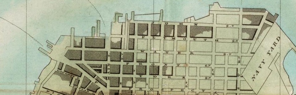
Lionel Pincus and Princess Firyal Map Division, The New York Public Library. (1767). Plan of the town of Brooklyn and part of Long Island. Retrieved from http://digitalcollections.nypl.org/items/871fda48-ba46-c1d9-e040-e00a18064c0a


Final Project Brooklyn 1827

Link to shared files:  https://github.com/coderhub/Brooklyn_1827

Created By: Carlos Merced
Date: May 25, 2016
Title: Brooklyn in the year of 1827

** Works in Firefox and Google Chrome updated browsers **

This 3d model of Brooklyn shows the land occupied or sold in 1827, along with rope walks and other building data. The blue represents occupied space and the tan color represents undeveloped or unsold land plots.

Click on index.html to view the interactive map.      Screen Shot 2016-05-25 at 6.47.18 PMScreen Shot 2016-05-25 at 6.47.34 PM

End of Semester Reflection

Here are the same prompts we discussed in class for an end of semester refection:

  1.  How do you view research differently after this class?
  2.  How does a  geographic viewpoint impact your approach to research and understanding of place?
  3. Will you use (and seek out) primary sources in the future? Why or why not?
  4. How can research in general, and place-based research in particular) be made more engaging?

Reflection: “Students can’t access essential research”

The main obstacle to access is the subscription fee journals require. They are very expensive, even for libraries, and their price only increases.  This makes the feasibility of purchase for individual students (most of whom have incurred prior debt) impossible, and for libraries, very hard. This has to do with hard financial times for students and institutions.

Summaries of important work could be paraphrased on Wikipedia, allowing students to get the gist of the research, without access to the source material. This requires those with access to reference that which they have read onto Wikipedia on a regular basis.

Reflection: Mid-semester

At the mid semester, I felt I had learned a lot about both the Vinegar Hill area, a topic of which I knew nothing about, as well as some techniques into gathering research data (and presenting it as well).  The concept of visiting archives was foreign to me as well.  Actually going to an archive (like the Brooklyn Collection at the BPL) was an illuminating experience, which will definitely prepare me if I need to visit one again.

Of particular interest were the NYPL maps collection, and the general introduction to GIS.  The NYPLs online collection was an amazing tool to use; the access to the maps I needed was seamless, and there were a lot of maps to choose from.  On the GIS side, CartoDB was a useful tool for me, due to my novice level at GIS mapping.  However, my background knowledge in data science and SQL made it a tool I could learn easily, if I ever needed to apply GIS.