Author Archives: Kyra Cuevas

End of the semester reflection

1. After taking this course, research seems much more tangible and much more enticing. I feel much more confident in finding sources, annotating them and utilizing them for a subject of interest. I was also satisfied with the numerous fields we have taken, some of which I never knew existed (the NYCHA archives at LaGuardia CC).

2.  As a design student, the idea of a geographic viewpoint has always been relevant. The specificity of geographic viewpoint, site, or location is a great enabler for students, as it may inspire them to further investigate why conditions were the way they were, why conditions have changed as well as the possible projection or invention of what could be made next. However, from a interdisciplinary standpoint, it is imperative to recognize the different methodologies used to extrapolate information.

3. I will most certainly use or seek out more primary sources in the future, as they are incredibly relevant to architecture, urban design and planning. Primary sources are often a critical ingredient for proper research, analysis and sometimes design proposals.

4. Research can be more engaging if the subject of interest is discovered earlier, and if the tools used to facilitate the research are well understood by students and are further demonstrated (i.e sketchup)

Reflections #8: Mid Semester Course Progress Reflection

I’m enamored by the growth I can see between myself, and other colleagues when it comes to progress between the mid semester and now. By the mid semester, I was pleased with both the amount of field trips we have taken and the new methodologies for research. Prior to this I was unaware of some of these institutions, such as the NYCHA library in LaGuardia Community College. Within these field trips, we were also asked to find quality sources, relative to our research. I can also say that I was unaware of some of the technologies introduced such as cartodb.com, which I have used heavily for the final project.

Reflections #9: Wikipedia and the Death of the Expert

“If learners are indeed doers and not recipients, from whom are they learning? From one another, it appears; same as it ever was.” The writer describes the definition of learning to be a two way street, which requires both “doing” and “receiving”. Learners may learn most effectively through interaction and hands-on experience or “doing.” Learners also benefit from other learners, as peer review or presentation is often pondered or “received”.

Wikipedia exacerbates this definition of learning, whereby users of Wikipedia are both doers and receivers. Users of wikipedia may “receive” numerous citations, but most effectively through reading effectively and through editing rigorously or “doing”. One of the comments I found funny, but relative was “How come Wikipedia hasn’t turned into a giant glob of graffiti?” By reading the article, I also learned that nearly two thousand administrators participate in maintaining Wikipedia.


Reflections #10: Students can’t access essential research

While research can be facilitated through the use of “Google”, the quality of research is questionable. “Essential research” or “quality research” on the other hand can only be accessed through privilege. Privilege can be defined by economic and academic status (having financial stability to subscribe to private data hubs, or university journals, databases etc).

Contributing to Wikipedia will enable anyone (regardless of economic or academic standing) to conduct quality research. The greater public will have access to these documents, which are often cited by the contributors. Citations also provide the greater public with access to the agencies in which the documents were derived from.


Reflections #11: Project Plan

For the final project, I plan on compiling a visual map which record NYCHA’s housing complexes. The intention is to analyze NYCHA’s housing properties in relation to their site conditions, and to see if there is a tangible connection between the typology of the site condition and date that the property was built. The typologies that will be utilized in this project are: edge conditions/neighborhood borders, waterfront/flood zoning conditions, medical center adjacency, and infrastructural fragment adjacencies. The study will be from the 1930’s to the late 1990’s.

Using CARTDB or a GIS software will enable me to precisely document these properties and parameters. I am hoping that this map can be an interactive learning tool for future students. Students should be able to freely zoom in and out of the map and hover over properties to learn about their basic information.


Reflections #7: GIS post & GIS as an aid for urban planners and designers


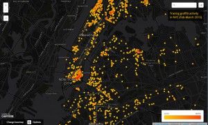
Tracing Graffiti Activity in NYC

It was enthralling to learn both about the genesis of GIS and the concurrent application of GIS. Although we did not use GIS on Thursday, we learned the basics on how to use a similar system called CartoDB. Above is screenshot of a map I had made from the website, which aims to study the pattern of graffiti complaints in NYC for the past month.

Both GIS and Cartodb function from a database in which information can be extracted to formulate visual representations. Visual representation or aids can facilitate different methods of analysis, or learning which are highly applicable for research and planning methodologies. While the art of mapping has started in the 1700’s, GIS has enabled multidisciplinary fields to track information in gratifying ways since the 1980’s.

Information can be understood in a series of plots, shapes or colors that in the context of the map, creates a new form of investigation. New patterns are plotted on a map, which are endless: they can can either be topography of a place, which is helpful for landscape architects, for tracking traffic accidents, which is helpful for transportation planners, for studying income brackets in a neighborhood, which is helpful for urban planners, and even for studying crime, which is helpful for the police force. All these possibilities make me feel quite fortunate to have access to these tools, as there is an endless sea of open databases on the web.