Monthly Archives: October 2015

Patience and Fortitude, or Wednesday’s visit to the Map Room of the New York Public Library

This Wednesday, October 21 we meet at 10 a.m. at the New York Public Library, 42nd Street between 5th and 6th Avenues (directions). We’re visiting the Map collection there and consulting with a map librarian, Artis Q. Wright, Library Specialist II of the NYPL Maps Division.

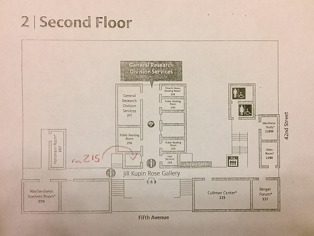
Take the B, D, F, or M trains to 42nd Street/Bryant Park, the 7 train to 5th Avenue, or the 4, 5 ,6, 7 or S to Grand Central/42nd Street. Enter the library at the main entrance (look for the lions, Patience and Fortitude), and head to the second floor to room 215 (click to enlarge):

NYPLfloorplan

For this Wednesday’s visit to the NYPL Map Room, please write a pre-visit reflection blog post (see previous post and assigned reading). Please also write a reflection blog post on today’s conversation with the Urban Design studio class.

On Monday, October 26 at 10 a.m. we visit the Brooklyn Collection at the Brooklyn Public Library, Central Library at Grand Army Plaza. Take the 2 or 3 train to Grand Army Plaza or the B41 bus to Flatbush Avenue & Grand Army Plaza; the library is across Grand Army Plaza from the subway stop; the bus stops directly across Flatbush Avenue from the library’s entrance. Let’s meet at 10 just outside the Brooklyn Collection on the second floor of the library (see floorplan). The library opens at 9; if you arrive early, there’s a cafe on the ground floor.

Please get in touch with any questions you have about where we are meeting and when.

~Prof. Leonard


Pre site visit NYPL

Post site visit:
The article “unbinding the atlas” brings up a question I’ve always thought about but never gave it more thought. I have to admit that this will be my first time in maybe 7 years (since high school, possibly) that I will be visiting a New York City library, and I’m quite excited. Especially to be utilizing it for the historic maps which are found online but there’s some that my class and I have learned are not online. The articles and historic maps are strategically posted online while the beauty of visiting a library the “old school” way is still there. And the decision to post them was questioned, my vote is against that because when you enter a library or use anything from there you assume that the source is creditable and you don’t doubt it. The web creates an uncertainty because anyone can post anyone.

Pre-Site Visit Reflection NYPL

I’m looking forward to our visit to the New York Public Library map room. I’m very fond of that library; when I was a kid I used to sit on the steps and talk to the lions, Patience and Fortitude. I got a library card as soon as I could print my first name, though I mainly went to my local branches to take out books. I’m also looking forward to the visit because I’ve never been to the map room and I’ve always liked looking at maps. I really like geography so I find looking at old maps very interesting. I collect city maps whenever I travel—and of course I collect subway/metro/underground maps.

Matthew Allen Knutzen’s article, “Unbinding the Atlas: Moving the NYPL Map Collection Beyond Digitization,” was fascinating. I hadn’t thought much—at all—before about the process of digitizing paper maps. It’s an amazing project: not just simply putting maps online, but coordinating them with all sorts of other data about the region displayed and making them searchable not just by area names but by coordinates of longitude and latitude. That means it will be possible to find a map of a region even if the region had a different name or was still unnamed. It will be possible to visualize the changes in a region over time. An earlier project discussed, Building a Globally Distributed Historical Sheet Map Collection—“centered on a set of 776 topographic maps published in multiple editions by the Austro-

Hungarian Empire from 1877 to 1914”—would have been incredibly useful for another class I’m taking right now on immigration history. My own ancestors came from the Austro-Hungarian Empire during exactly those years.

It will be interesting to see the NYPL’s map collection, hundreds of thousands of maps spanning centuries—and it’s exciting to think that in the future I’ll be able to search many (most? all?) of this material online.


Daiane Bushey | First (and secondary) Sources Post

Scans-10-07-2015-130513_2_of_48

1 -Brooklyn: An illustrated History by Ellen Snyder-Grenier (Book)

  • ISBN-10: 1566394082

2- Towards the end to be achieved; the New York city housing authority, its history outline

3- Brooklyn Navy Yard (Photographs glued together into manila folder to create detailed view of location)

4- Fail of House Regulation

5- Brooklyn Then and Now (Book)

  • ISBN-10: 191049657X

NYPL map room visit next week, and Wikipedia reminders

It was great to see different working groups pull together lists of primary and secondary sources on the course site. If you and your group have not yet posted a list of resources, please do so as soon as you can.

During class time next Wednesday 10/21, we’ll visit the New York Public Library map room. We will meet at 10 am in room 215 of the Schwartzman Building at 42nd Street between Fifth and Sixth Avenues. It’s the famous building flanked by the lions, Patience and Fortitude. In advance of our visit, please write one pre-visit reflection blog post by next Wednesday morning. Please read pages 1-5 and the conclusion of the following article and incorporate your thoughts on it into your post:

Knutzen, Matthew. “Unbinding The Atlas: Moving The NYPL Map Collection Beyond Digitization.” Journal Of Map & Geography Libraries 9.1/2 (2013): 8-24.

You’ll need to authenticate with the barcode on your City Tech ID card to access the article.

Annotated Bibliography guidelines were distributed in class. Each group will produce one annotated bibliography. The draft is due on November 9 and the final on November 11.

Wikipedia reminders: if you haven’t done so already, create a Wikipedia account and send me your username so I can add you to the WikiEdu course site; be sure to complete the online training as well. Don’t forget, the Wikipedia Edit-a-Thon takes place tomorrow (Thursday 10/15) between noon-8 pm at the Guggenheim Museum on Fifth Avenue and 88th Street. Register and help improve Wikipedia articles on women in architecture.

~Prof. Leonard

Primary Sources

1.Police Department City of New York Compstat
This link shows crime statistics for the 84th Precinct.
http://www.nyc.gov/html/nypd/downloads/pdf/crime_statistics/cs-en-us-084pct.pdf

2.Police Department City of New York Moving Violations
This link shows the traffic reports for the 84th Precinct.
http://www.nyc.gov/html/nypd/downloads/pdf/traffic_data/mv-en-us-084sum.pdf

3.”Mayor de Blasio, Comptroller Stringer, NYCHA Chair Olatoye Announce Beginning of Security Camera Installation at Boulevard Houses and Five More Housing Developments Around the City”
The official website of the City of New York;Pressoffice;June 11 2014

Proposition for providing NYCHA buildings with new cameras.
http://www1.nyc.gov/office-of-the-mayor/news/282-14/mayor-de-blasio-comptroller-stringer-nycha-chair-olatoye-beginning-security-camera#/0

4.”14 Charged in Drug Trafficking at Brooklyn’s Farragut Houses: Over
100 sales of narcotics, 3 firearms seized”
Office of the Special Narcotics Prosecutor for the City of New York;PDF

Information about a drug bust in the Farragut Houses, showing unsafe practices around the area
http://www.nyc.gov/html/snp/downloads/pdf/Farragut.pdf

5.”Newly Refurbished Gymnasium at Farragut Houses in Brooklyn:
Funding through Seized Narcotics Proceeds”
Office of the Special Narcotics Prosecutor for the City of New York;PDF; July 15, 2015

This shows the proceeds of the narcotics bust going to good use in a gym for the Farragut houses, showing that some good can come out of some bad.
http://www.nyc.gov/html/snp/downloads/pdf/farragut_houses_071515.pdf

Darya | primary sources: Built Environment

1. New York City Library. OldNYC

Map with old 1850-1950 pictures of the New York City

2. Brooklyn Library Historical Newspapers

Collection of the Brooklyn Eagle Articles

3. New York City Library Historical Maps

Digital collection of the old maps in New York Public Library

4. VINEGAR HILL HISTORIC DISTRICT DESIGNATION REPORT 

Report about historical District of the Vinegar Hill.

5. http://catalog.brooklynpubliclibrary.org/

Digital collection of the old pictures in the Brooklyn Public Library

Five Primary Sources: Technology

Five Primary Sources for Water Infrastructure system by the time of technology development.

1. Book Title: Brooklyn! An Illustrated History
Author: Temple University Press, Philadelphia 19122
Published 1996

Available at NYCCT Ursula C. Schwerin Library Reference (F 129 .B7 S69 1996).
http://onesearch.cuny.edu/primo_library/libweb/action/display.do?tabs=detailsTab&ct=display&fn=search&doc=dedupmrg197290413&indx=1&recIds=dedupmrg197290413&recIdxs=0&elementId=0&renderMode=poppedOut&displayMode=full&frbrVersion=&dscnt=0&scp.scps=scope%3A%28CUNY_BEPRESS%29%2Cscope%3A%28NY%29%2Cscope%3A%28AL%29%2Cprimo_central_multiple_fe&frbg=&tab=default_tab&dstmp=1444754166837&srt=rank&mode=Basic&&dum=true&tb=t&vl(freeText0)=brooklyn%20an%20illustrated%20history&vid=ny

This book introduces a brief of history that why tenement building in Brooklyn waterfront area had become ‘slum area’ in 1850’s.

2. Government official website.
New York City Department of Environmental Protection
History of New York City’s Water Supply System
Available at http://www.nyc.gov/html/dep/html/drinking_water/history.shtml
This article introduces not only a history of New York City’s water supply infrastructure, also today’s water supply system and regulations too.

3. Magazine: Popular Science: vol. 35
Published in December 1932
Title: World’s Longest Water Tunnel
Available at https://books.google.com/books?id=iigDAAAAMBAJ&pg=PA35#v=onepage&q&f=false

The article introduced new technology in water tunnel system and its pros and cons.

4. Book title: The Encyclopedia of New York City
Publisher: New Haven : Yale University Press ; New York : New-York Historical Society, 1995
Contributor: Jackson, Kenneth T.
Available at New York Publick Library
https://nypl.bibliocommons.com/item/show/12321485052907_the_encyclopedia_of_new_york_city

This book contained the information about New York City’s first public water system: collect pond.

5. History of Plumbing in America
First published in July 1987, P & M magazine
Available at https://www.plumbingsupply.com/pmamerica.html