Monthly Archives: October 2015

Post-Visit Reflection: New York Public Library

I really enjoyed our visit to the New York Public Library map room. I’d been to the library many times, of course, but I’d never been to the map room before. I didn’t even know it existed!

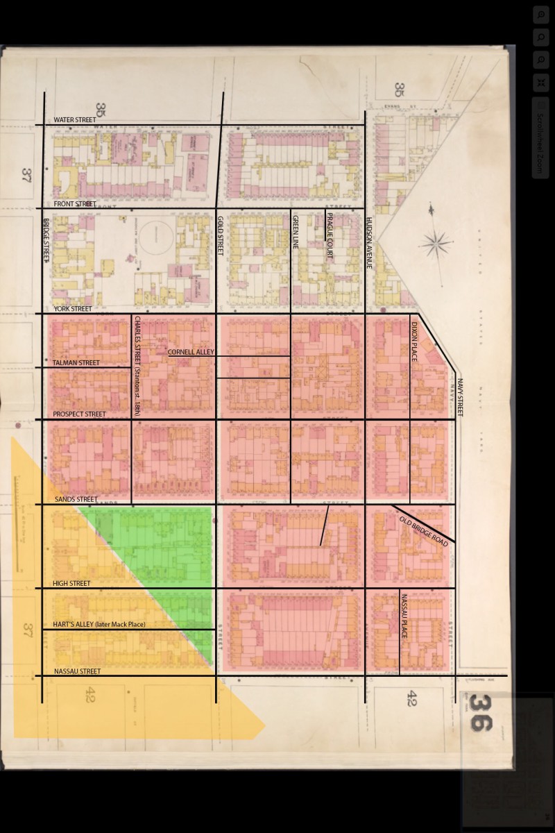
I looked at many different maps of the area around the Farragut Houses, generally known as DUMBO, downtown Brooklyn, and/or Vinegar Hill. I found lots of interesting information about the street layout and how it changed over the years. The most interesting thing actually was the fact that it didn’t change very much until the Farragut Houses were constructed.  At that point, the neighborhood was demolished. Streets disappeared, were deleted, replaced by superblocks.

I didn’t find a lot of new information about transportation to the area—the main topic of my research project—because transit maps were not made available to us during our visit to the library. I did find one page in one book relating to the subway system, however, a map showing plans for the second system, the city’s planned expansion of the subway right before the Great Depression. The Depression derailed the plans, and then World War II killed them entirely: there were no workers around to do the building and all available iron and steel was needed for the war effort. One part of the planned system, the Second Avenue subway, is still under construction today.

It was very meaningful to me to be surrounded by all those maps, the physical record of our changing city. I find maps—especially paper maps—fascinating, almost poetic, a way to be in touch with history. I’m glad I discovered the NYPL map room. I’m sure I’ll return.

Daiane Bushey | NYPL Post Site Visit Reflection

Our visit to the New York Public Library was really instructive because it put all the students in contact with physical maps of the Vinegar Hill area. (Before, we were mainly looking on digital versions of maps of that region). We had access to entire books of maps so,  just by flipping a couple of pages,  we also saw many maps from adjacent areas and maps from different decades. It was interesting to learn that those map books used to be updated just by gluing paper with the new information on top of the old maps. Also, it was really fun checking Google Maps and  contrasting it with the books, comparing what was like in the past and how it is right now.

Brooklyn Public Library Monday, and site reports

On Monday we meet at 10 a.m. at the Brooklyn collection at the Brooklyn Public Library, Central Library at Grand Army Plaza. The 2 and 3 trains stop at Grand Army Plaza, and the B41 bus stops across the street from the library entrance at Flatbush Avenue and Grand Army Plaza. The Brooklyn Collection is located on the 2nd floor of the library. Bring sketchbooks/notebooks, pencils, and your phones or cameras to document the primary sources in a variety of media — photos, newspaper clippings, maps, manuscripts — that we’ll study.

Site reports for the NYPL map collection visit are due on Wednesday, October 28 posted to the OpenLab. Don’t forget to post your post-site-visit reflections!

See you Monday!

NYPL Post Site Visit Reflection

Our visit to the NYPL turned out even better than i expected. Like i said in the pre-site reflection, I have never been to a library bigger than the one at City Tech. The amount of information I was able to collect in that one hour was amazing. My research topic is the built environment of the area, specifically what was there before the Farragut Houses. In the one map book alone, I was able to record with great detail what each building was at the site in 1941. These maps also told us what the buildings were made of, and if there were any commercial spaces in the building. This was exactly what we needed, since the demolition of this area occurred only a few years later. I hope to have the opportunity to go back to the NYPL and look at other maps and resources to further help our research.

NYPL reflection

Unfortunately my classmate and I ended up at another library and not the main branch located on 42nd street . After we got to the China Town public library as Google maps directed us the librarian there gave us directions as to  where we can access the  F train that would lead us to the main branch on 42nd street. Even though we did not get to look at any of the  maps in the map room (room 215) I did manage to gather some information about the Farragut houses in the remaining class time at the NYPL. I  asked the librarian for assistance and was assorted to a section where I  saw one map of the area where the Farragut houses were built in a book titled, “BROOKLYN  NY VOL 12”. Although this visit wasn’t a huge success for me I do plan on revisiting the library sometime soon to look at as many maps as possible in order to better understand what that piece land was used for before everything was completely demolish and to also gain a broader perspective of the current and future of NYC Public housing.


20151021_123048[1] 20151021_123037[1]

DARYA | post- reflection on Urban Studio and visit architecture department

Architecture students brought new ideas to me about how I can differently look at the space. What I’ve learned from their projects is that open space is not safe and to make area safer it’s better to divide blocks and put more objects there. To make it safer they also want to build more commercial and residential spaces to make area more alive. Also i think it was a good idea to mix people by building luxurious and low-income places. At the same time all that projects were very modern but I really like the idea of historical district and it’s different from any other place stile. I was surprised how much work was done and how much ideas this student can bring to this world.

The Urban Studio visit clarified the idea of our project and I finally realized the main purpose of our research. The exhibition shows how beautiful and interesting we can present our work and make a good contribution into the data base of the New York history. The Urban Studio presented the history of one of the buildings of City College of Technology, the Mosaic Building. The exhibition includes 3D paper models of the area and architecture, historical timeline, pictures of the important  people who were working on the project. The story of the main element of the building, its symbolic and the author of it. It is the good example for us of how we can present our work.

Darya | NYPL pre-visit reflection

image

Very exited to visit the library. As I was looking at the maps all this time and going deeper into the old pictures I hope to see more pieces that are not possible to see in digital version. Question if it will be possible to take a copy of them?

I want to look at the names in historical section. And, of course, to make a research in books about NYCHA and downtown Brooklyn history.