Tag Archives: mapping brooklyn

Mapping Brooklyn-BRIC

Unfortunately, I lost the name of the art work, but my favorite piece in the exhibit are the three videos that are hanging off the walls in the upstairs room. In each video it shows a different locations in NYC over the course of several years and the innovations in such communities. I thought it was just simply amazing that in the midst of 6 years, a vacant lot with a forest in it turned into a series of beautiful condos. In addition, I was able to see the gradual progression of the construction being done, which I thought was very interesting.

I think I gravitated toward this piece of art because all my life I lived in Park Slope. Unfortunately, due to a fire I was forced to leave the only place I called “home”. I don’t visit much because it is so far from where I currently reside, but recently I was able to walk the entire neighborhood on a stroll with my boyfriend. After my pleasant stroll, I can honestly say I barely recognized it. Over the eight years I stopped going to Park Slope, I can say maybe a handful of the places that are on the old block I used to live on, are still there from my time.

As much as I miss my old neighborhood, and walking everyday on 5th avenue, I have to admit that the innovations that have occurred in the past eight years, are amazing. To bad it wasn’t like this when I lived there.
Mapping Brooklyn

“As an artifact, land-and the structures we build upon it-carries our experiences, memories, and voices.” I appreciated this quote by Jennifer Maravillas. 71 square miles from 2012-2015 it took her to walk and collect a piece of litter paper to create the 10 x 10 map. For someone to take that much time and effort to create and share this map with us, that interested me. I don’t believe my perspective changed on maps, but it did remind me how small we are in this vast universe. If I could visualize my daily life on a map, I would probably want to capture those unforgettable moments I’ve had in my life, in the different locations they took place on a map. It would be interesting because I can look back at my life when I get older (younger), and possibly share it with my family in the future.

Mapping Brooklyn:William Maldonado

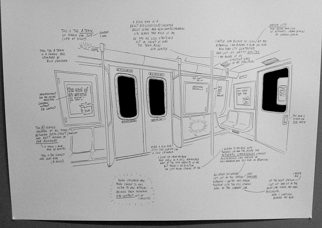
The map that captured my interest the most was the map by Sharon Zukin because it didn’t really look like a map due to the fact that is wasn’t from a sky view or include different sections of a city but just simply her view while sitting in the A train at 1am. This broadened my horizon to thinking that anything in our sight is a map as long as it could be mapped out. That it doesn’t necessarily need streets to be considered a map. Sharon proved that in that drawing of her ride home the way she mapped out not only what she saw but also what she thought about what she saw.

Sharon Zukin – Naked City

20150401_104024

Mapping Brooklyn wrap-up, and spring break bonus blogging

Today we visited the Mapping Brooklyn exhibit at BRIC. For one bonus blog post point (due by 10 a.m. on 4/13/15), write a 100-word blog post in response to the following questions:

What map was the most interesting to you and why? How did viewing this exhibit change how you perceive maps in daily life? What information or data in your daily life would you like to visualize on a map? Why would it be helpful or interesting?

I distributed guidelines for the next research-paper-related assignment: the outline, due April 15. I’ll post guidelines for the research paper draft over spring break and distribute them in class on April 13.

Enjoy spring break, and remember, the City Tech library is open Monday-Friday 9-5 if you need a quiet place to study, use a computer, or print.

~Prof. Leonard