Ebola in graphics
The toll of a tragedy
Mar 12 th 2015, 11:30 by The Data Team
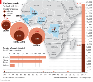
THE first reported case in the Ebola outbreak ravaging west Africa dates back to December 2013, in Guéckédou, a forested area of Guinea near the border with Liberia and Sierra Leone. Travelers took it across the border: by late March, Liberia had reported eight suspected cases and Sierra Leone six. By the end of June 759 people had been infected and 467 people had died from the disease, making this the worst ever Ebola outbreak. The numbers keep climbing. As of March 10th 2015, 24,350 cases and 10,004 deaths had been reported worldwide, the vast majority of them in these same three countries.
The outbreak continues to claim lives, but Liberia had no confirmed new cases for a second week. Sierra Leone is still struggling with widespread transmission and cases continue to be detected from unknown sources across the whole region. However, the World Health Organization reports that each country now has enough treatment beds to be able to isolate and treat patients with Ebola, and to bury everyone known to have died of the disease. The chart above shows numbers from both the WHO’s regular situation reports and from patient databases till Mar.10th 2015.
Reproduction of the chart:
The map of Africa shows the Ebola hit countries in blue color, which are mostly in south-west African countries, with Sierra Leone, Liberia and Guinea most severely hit.
The color circle graph indicates the infected number of people and those dead in countries where Ebola break out till March 10th 2015. The 3 heavily-hit countries are Sierra Leone, with 11,677 people infected, and 3,655 dead; Liberia with 9,343 people infected and 4162 dead; and Guinea with 3,330 people infected and 2187 dead.
Below the circle graph is bar graph tells us number of people infected per 100,000 population, with Liberia having the highest rate of infected people about 250 infected every 100,000 people.
At the bottom of the map is a horizontal line (serves as year) and vertical bars (act as infected number of people and those dead) making bar graph. The bar graph tells us from 1976 to 2015 there are 10 outbreak of Ebola in all in south-west African countries, of which the outbreak beginning with 2013 is the biggest disaster, up to 24,350 people infected and 10004 dead till March10th, 2015.
The map of Africa with 3 graphs is used to tell us the data about Ebola outbreak in African countries since 1975.


Reference (link)? I think what you have s too long. Instead of spending the whole time explaining the issue, focus on the graph itself. How is the graph being used in the article? What do YOU learn when you study the graph?
Your graph is very interesting and you have many great details and elaborations on Ebola’s outbreak in African countries, but you should shorten it a little and explain the graph in your own understanding. Also, it would be great to see the site where you got your information from.