1-What is the map’s call number?
Pierrepont – [18-?] a. Fl
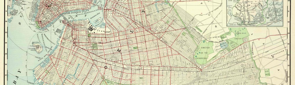
2-What is the map’s title (if available)?
Map Of Some Streets On Brooklyn Heights
3-Which collection does the map belong to?
Pierrepont
4-When was it made?
1800s
Physical description of the map:
5-What size is the map (approximately)?
1 1/2 ft. by 2 1/4 ft.
6-What colors does it use?
Black and white
7-What materials were used to make the map?
Parchment, black ink, and pencil.
8-Who made the map?
M.B.
Map content:
9-What location does the map depict?
Brooklyn Heights
10-What details does it include?
Properties, sizes, and streets.
11-What time period does the map depict? Is this the same as the time when it was made?
1800s, the same time the map was made
12-What is familiar to you about the location depicted in the map?
Fulton Street and Court Street
Interpretation and Reflection:
13-What is the purpose of the map?
To show properties and street locations
14-Why did it survive prior to becoming part of the archives at BHS?
Maybe the map was made by somebody of great importance or somebody decide it would be useful in the future.
15-Why did BHS incorporate it into its collections?
The map is of Brooklyn Heights and it is relevant to the society
16-What is familiar or unfamiliar about the map?
Court street, Fulton street, and Public Square are familiar. Some of the alley ways and other streets do not exist today.
17-What additional information would you want to better understand the map?
A legend, compass, and scale.
18-Where is City Tech in relation to this map?
City Tech is not on this map but if it showed you Northeast of Public square, it would just be a couple blocks away.

