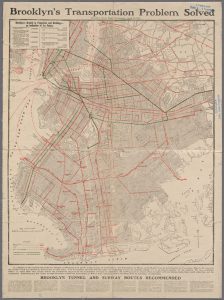
After the class on Monday, I realized transportation is a vital aspect to development of any neighborhood. I initially thought that I would only find a few transportation lines near vinegar hill. I thought this simply because there doesn’t seem to be much development in the present day. After seeing the transportation map which was originally published by the Brooklyn Eagle in 1905, I was surprised to see how developed Brooklyn was with seam railroads, elevated railroads, cable railroads, and trolly and horse railroads. I was even more surprised to see the proposed subway lines though. Because I originally assumed transportation guides development, I think that in Brooklyn, development shaped the need for transportation. Moving forward I would like to look into the neighborhoods where the proposed subway trails are, maybe I will answer my own question or strengthen my theory of development. As for Vinegar Hill, I feel like it has always been a forgotten chunk of land. In this map it only shows one line of transportation, although it does not show which kind, I am assuming a trolley system. That as well needs more research.
Lionel Pincus and Princess Firyal Map Division, The New York Public Library. “Transportation map of Brooklyn, Improvements shown on verso (separate sheet.)” The New York Public Library Digital Collections. 1905. http://digitalcollections.nypl.org/items/09f48090-cf88-012f-34c8-58d385a7bbd0


