Vertical Stage
PROJECT OVERVIEW
In this project students will be introduced to strategies for documenting and analyzing site conditions with the intention of using this information to develop a site-specific design proposal. Students will be expected to thoughtfully develop a design language that achieves a meaningful connection to the site while interweaving given programmatic and environmental parameters.
Students will continue exploring design and tectonic elements of line, plane and volume through site documentation and analysis, drafted projected drawings, collages and iterative model making. The goal is to amplify systematic thinking and strategies for developing a cohesive design language while constructing programmed inhabitable spaces.
There are three main programmatic components involved in the design process:
• The design of a vertical structure to experiment with vertical circulation while hosting performative functions.
• The design of an entry from the city to the park that engages horizontally with the site as an active threshold.
• The subliminal space in between the two bi-axial structures curated as a connecting landscape.
The project will be divided into two phases:
Phase 01: The Vertical Stage and Phase 02: The Urban Threshold (Information Center) and connecting fabric between the two structures. The Intention being this being the consideration of expansion and revisiting and developing a connect design language.
OBJECTIVES
• Exploration of natural and formal ordering systems and their capacity -to inform in two and three-dimensional design (SPC A. 5)
• Articulation and Development of a design through iterative process
• Refinement/evolution of design language during phase 2 of the project
• Documentation and Analysis of site/context
• Development of Architectural ideas/concepts relating to the activation of space through notions of inhabitation and circulation; horizontal vs vertical movement, enclosure, bridging, transition, program and experiential events.
• Development and generation of Models and Graphic representation to reflect design intentions
• Understanding and exploring concepts of scale, proportion and order
THE SITE
The site is located at the south west corner lot at the intersection of 10th Avenue and E20th street. The current use of the lot that will be replaced with your design of the Urban Threshold.
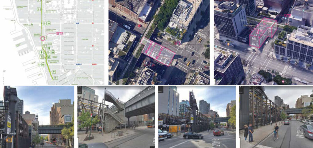
The High Line is a 1.45-mile-long (2.33 km) elevated linear park, greenway and rail trail created on a former New York Central Railroad spur on the west side of Manhattan in New York City.[1] The High Line’s design is a collaboration between James Corner Field Operations (Project Lead), Diller Scofidio + Renfro, and Piet Oudolf. The abandoned spur has been redesigned as a “living system” drawing from multiple disciplines which include landscape architecture, urban design, and ecology. Since opening in 2009, the High Line has become an icon of contemporary landscape architecture.[1]
For more information got to www.thehighline.org
Notes:
- Keller, Jared (July 2011). “First Drafts: James Corner’s High Line Park”. The Atlantic. Archived from the
1.3 Program + Project development
2D Drawings with Site
Program to include:
- Small Storage
- Public Bathrooms
- Small Stage
- + Program of your choice in support of your argument
DELIVERABLES
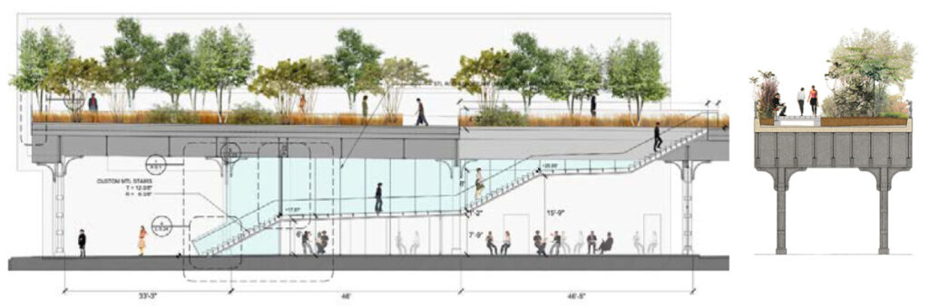
- 3 Sections (long and short)
- 3 Floorplans (at High Level, Street Level, at Lower Level)
- Site Plan
- 2 Elevations (North and East)
CONSIDERATIONS
All drawings should consider:
Levels of enclosure
Relationships between levels
General Proportions between parts,
Programmatic uses
Organization of circulation
Relationship to human scale
Relationship between your project and its surroundings
etc.
TYPICAL LAYOUTS
TEMPLATES
1.2 Concept development
A) Collages
Based on the research and site analysis (1.1) create collages to frame your ideas/observations and responses toward the Highline and your site. Use these observation to explore form by creating an abstract collage of spatial possibilities.
REFERENCES
See collage references on Proj. 2 MIRO board.
DELIVERABLES
- 1 Argument collage
- 1 Formal/Spatial collage
- Short statement
Using your Formal/Spatial collage, develop a series of 3D studies in Rhino, translating 2D to 3D.
B) Digital Concept Model
Based on the formal/spatial collage, and in support of your argument, start translating 2D abstract forms into 3D geometry.
To consider:
Access, Ascension and Dissension, Directionality, Duration, Hierarchy, Measure, Orientation, Patterns, Rhythm, Scale, Sequence, Surface, Textures, Thresholds, Time, Transition
To negotiate:
Constant/change, Dense/sparse, Fixed/Flexible, Heavy/light, Light/shadow and shade, Loud/quiet, Old/new, Open/closed, Point/counterpoint, Radial/axial, Movement/repose, Near/far, Slow/fast, Thick/thin, Vertical/horizontal
DELIVERABLES
A series of min. 3 Concept Model trials exploring 3D form in Rhino.
REFERENCES
1.1 Research and Site Analysis
An important part of the design process is based on understanding the site and its surroundings. Often, design proposals and solutions are a direct response to the relationship between programmatic needs and location. Our first task is to obtain a thorough understanding of the site so that we can start making design decisions.
Practical skills:
The students will generate a series of grids to establish order, rhythm and proportion in a 2-D abstract field. Once the grids are established, they will be manipulated to create 3-D space within a given volume.
CLASS DISCUSSION
Project Introduction
Site analysis and documentation
Understanding building and environment parameters
Critical Observation
Layout Composition as a visual Narrative
A) Group Research
Work in groups to research the following thematic categories and buildings:
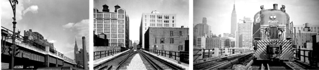
TEAM 1: TRAINS + THE HIGHLINE + THE SHED
movement, wagons, engine, tracks, etc.
TEAM 2: NEW LUXURY + THE HIGHLINE + HL23
city fabric, developers, scaffolding, private/public, gentrification, etc.
TEAM 3: ART + THE HIGHLINE + THE NEW WHITNEY
art galleries, theater, performance public/private, etc.
TEAM 4: FACTORIES (INSDUSTRY) + THE HIGHLINE + CHELSEA MARKET
meatpacking, warehouse, loading, chimneys, etc.
TEAM 5: NEW PARK + THE HIGHLINE + PIER 55
nature, materials, textures, public furniture, pedestrian, tourist, playground, etc.
HINTS & TIPS
a) When you research and analyze a thematic category, like: Trains, New Luxury, Art, Factories, New Park, Bridge:
● Create a list of items, looks for connections and historic evolution
● Find relevant images (photos historical and current, sketches, diagrams, drawings, etc.)
● Most important: what is the relationship of the research subject to the highline? What are your thoughts, opinions and observations? What questions come to mind? Use bullet points and sketches to communicate your insights
b) When you research and analyze a building, like: The Shed, HL23, The New Whitney, The Chelsea Market, Pier 55, The Vessel
● Search for existing Diagrams, Concept, Narrative – read the project descriptions
● Most important: What is the story of the project and how does it relate to the Highline?
● Facts (year built sqft, etc.)
○ WHO | WHEN | WHY | HOW | WHAT
○ History, location, materials, etc.
○ Who is the architect, who is the client, who occupies or uses the building?
● Drawings (Floorplans + Sections + Elevations)
● Images (Exterior + Interior + structure or detail or during construction)
● What was on the site before? Future plans?
DELIVERABLES
- approx. 10+ slides on MIRO, approx. 3-7 min. presentation
RESOURCES
Wikipedia, architect’s official website, archdaily, dezeen, architect magazine, The New York times,etc. Make sure to call out your source, by including the name and author of an article, or link, etc.
B) Site Analysis: Diagramming
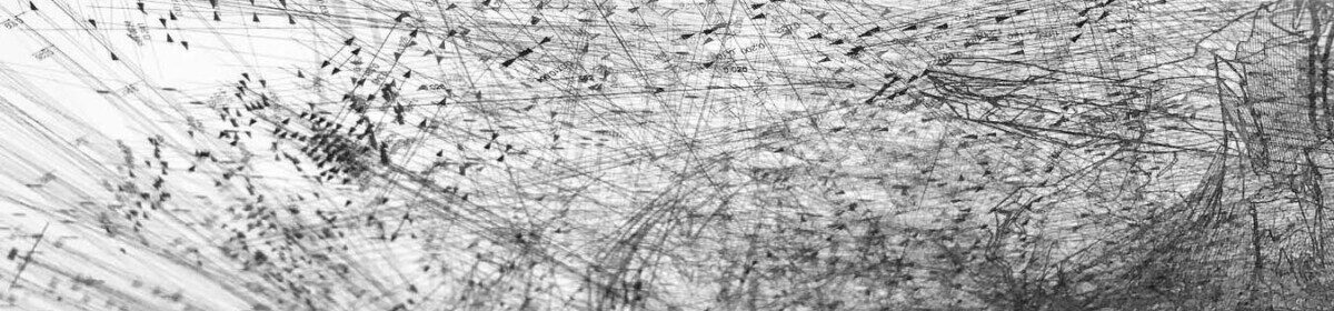
The analysis portion of the assignment is intended to highlight aspects that were discovered during the virtual/physical site visit and that will be used as drivers in the design solution. These observations are to be expressed through the generation of diagrams / information graphics: visual representations that get an idea across. This can be accomplished through the production of sketches, mappings, overlays on images and drawings and collages amongst other. These diagrams are intended to capture with more clarity conditions that otherwise would be impossible to capture or convey through a photograph.
Work in groups to analyze the following areas:
GROUP 1
- Public / Private
- Land Use
- Site attractions
GROUP 2
- Green areas + Vegetation
- Hardscape / Softscape
- Sun Path
GROUP 3
- View corridors (to and from the site)
- Facades
GROUP 4
- Access/ Accessibility (circulation patterns)
- Walking Radius
GROUP 5
- Pleasant / Unpleasant Factors or atmospheres
- Building heights
DELIVERABLES
- a number of diagrams, 2D or 3D, posted on MIRO
RESOURCES

