Monthly Archives: November 2016


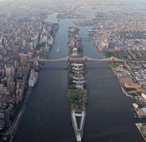
Roosevelt Island! But the Indians called it “Long Island” and the first Dutch owners knew it as Hogs Island – far off farm property in the middle of the East River.

The Blackwell family, taking possession of the island in 1676, held it for over 150 years, mined its quarries, farmed its fruit trees and during the post Revolutionary era built its now restored farmhouse, Blackwell House.

In 1828, New York City purchased the Blackwell’s Island for $32,500. South of today’s tram station a vast penitentiary soon was erected. The first of the innumerable city institutions to sprawl across the Island and hold millions of New Yorkers, small and great, it set the scene for decades of architectural, social and medical advance and defeat.

Description on Roosevelt Island Tsering Gurung

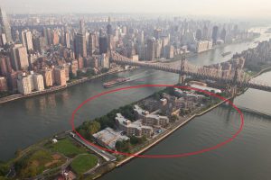
Roosevelt Island is narrow island where its located between Manhattan Island to its west and the brought of queens of Long Island east.  The total area of the Island is 147 ares and the population of the people living there is around 12,000. It is a very expensive place to live in, mostly people who are  rich can afford to live there. Because, the house rents for one bedroom is more than 2,000 which demands less people living in these area. The population of people has not been increasing rapidly throughout the year.  The building that were built in Roosevelt Island was around 1835 and it called the octagon which represents as the metropolitan hospital building. This building was closed in 1955, leaving the building abandoned. After many years of decay, as well as two fires that nearly destroyed the building, the Octagon was renovated and turned into a residential building. Its the history, From 1916 to 1957, a trolley that ran across the Queensboro Bridge stopped mid-bridge so passengers could alight on the island, said Judith Berdy, the historical society president. They descended by elevators inside a nine-story storehouse. To board the trolley, passengers entered kiosks in Manhattan or Queens. In 2007, the society moved and restored one of those terra-cotta structures, opening it as a visitor center on the site of the storehouse, demolished in 1970 to make way for the tram. (ny.timed.com

)bridge

sources: http://www.nytimes.com/2014/11/09/realestate/the-quiet-manhattan-roosevelt-island.html?_r=0


Urban Planning- Cory Breegle

Roosevelt Island is arguably one of the more isolated areas in New York City, having a completely different atmosphere than the majority of Manhattan. Technically belonging to Manhattan, Roosevelt Island, which was designed by the office’s of Philip Johnson and John Burgee, was designed in three phases.

Phase 1: known as Northtown, consisting of the WIRE buildings (Westview, Island House, Rivercross, and Eastwood), where Rivercross is a co-op and all the others are rental units.

Phase 2: funded mostly by Federal Housing financing, the property utilizes Section 8 housing program to allow lower income families to live in the units.

Phase 3: Known as Southtown, or the Riverwalk, is still under construction and was designed by SLCE Architects, Gruzen Sampton LLP, and Costas Kondylis and Partners LLP. The Riverwalk will have 9 buildings when completed, all used for residential, with commerce on street level.

riverwalk_banner

Sources:

http://hudsoninc.com/riverwalk-roosevelt-island/

http://affordablehousingonline.com/housing-search/New-York/New-York-City/Roosevelt-Island-Northtown-Phase-II/21269/

http://rooseveltislander.blogspot.com/2013/11/roosevelt-island-southtown-riverwalk.html


Cory Breegle

Roosevelt Island: Morris Schneps

Roosevelt Island was first purchased in 1637. In 1796, Jacob Blackwell constructed the Blackwell House. Today, the Blackwell House is the sixth oldest house in New York City. In the 19th Century, there were hospitals and a prison on the island. The island was purchased by the city of New York. In 1900 the Queensboro Bridge started construction. It passed over the island, however it did not provide vehicular access. In 1930, a vehicular elevator was built. In 1955, the Welfare Island Bridge was opened. This allowed vehicular access from Queens. The vehicular elevator was shutdown and demolished in 1970. Architects Philip Johnson and John Burgee created a plan for apartment building housing 20,000 residents. The plan divided the island into three residential communities and discouraged automobiles. One year later, the island was renamed in honor of Franklin D. Roosevelt. Today, people can use the subway, tramway, or the Welfare Island Bridge to travel to the island. Approximately, 12,000 people live on Roosevelt Island.

roosevelt-island-aerial

Morris Schneps