ZONNING
Zoning Quizzes are graded and posted in Blackboard
A couple of notes on the quizzes.
I had clearly indicated that in order to get credit for an answer
YOU MUST SHOW ALL YOUR CALCULATIONS.
Just putting down an answer gets no points!!!! Many of you lost a lot of points due to this.
When taking a quiz please be sure to read questions and instructions carefully.
Assignment Clarifications
Due for Monday:
Zoning Drawings and Citations
- Teams are permitted and encouraged to share their zoning research
- You are not permitted to share your drawing files.
- Z-101. Each individual student must be ready to present and hand in a set of zoning sheets for grading. The zoning drawings must be done in Auto cad (not Rhino or any other program). Sheet size is 22 x 34 – use the template titleblock provided. If you need more than one sheet you can name then Z-101.1, 101.2 or Z-101.A, 101.B etc.
- Z-102. Each individual student must have their own set of citations formatted on a titleblock. These can be either done in AutoCAD or Illustrator. Again if you need more than one sheet use Z-102.1, 102.2 or Z-102.A, 102.b, etc.
- The sheets for each individual must include your name and your team member names. Please print these to PDF and combine them
- Then all of a teams PDF files for zoning need to be composed into a single PDF.
- I will create a blackboard assignment and these will need to be uploaded by the end of day Monday. On Blackboard you will be required to include your original AutoCAD files or illustrator files.
Inventory and Analysis
- This work is a complete team effort – including the research and the drawing. As part of the assignment your team must include a credit slide that explains what each team mate did as part of the assignment. Each team mate should write this up for themselves. This should be the last slide.
- Format is also 22 x 34. The work should be printed to PDF for review. Title each drawing carefully by category (circulation, views, etc. and type (inventory or analysis)
Due for Second Class of the Week (Wednesday or Thursday)
- Complete building analysis. Also team work. You must draw this as a team in AutoCAD. This is also a team effort. We have reviewed this enough in class that you should be clear on what you need to look to explain.
- Each team will need to hand in their Autocad files and you should print your work to PDF so we can use the projector to review it.
- As with the other team work the last slide of your presentation should list what each team member did. Allow each team member to write this out for themselves.
There will be posting deadlines for uploads to Blackboard
- Monday February 29 – by midnight – posting of zoning and inventory and analysis
- Thursday March 3rd by Midnight – Building Analysis
PDF Tutorial for Compiling Site Maps in Illustrator
Hi all,
Step-by-step PDF tutorial for compiling site maps in illustrator has been posted under Agendas & Lectures & Tutorial > Day 5.
Titleblock has been updated as well to fit 34″x 22″ size. Here is a downloadable link to the illustrator file:
https://www.dropbox.com/s/wvsa2mgaca63zlz/34×22%20Board.ai?dl=0
Jieun
Be Ready for Class on Monday!!!
It is important that each and every team is prepared for class on Monday. There are two critical tasks you are working on.
First: Zoning
Each team must have their zoning document ready for review – and ready means the work is done as far as you understand it – so that we can go over it together. This does not mean you are figuring it out for the first time – and I can tell the difference when I talk to you. Each member of the team must be able to demonstrate familiarity with the zoning issues for their site.
Second: Site Inventory and Analysis
Each team must have base maps at two scales as discussed and demonstrated in class. Each team must already have made overlays of the different categories as outlined and demonstrated in class. Maps will be reviewed and marked up in class. As with the zoning each team member must be able to demonstrate an understanding of the inventory and analysis issues for their sites.
Please be on time to class.
Current Assignments
You should as a team be working on a number of assignments:
- Building Analysis and Development
- Site Inventory and Analysis
- Zoning Studies
- Construction photos
I would like to remind you that each team must build a simple model and it must be brought to class each day.
Site Inventory and Analysis Guidelines
Inventory : An inventory is a count – it identifies what things are and where they are. It does not qualify whether they are good (an asset) or bad (a liability)
Analysis : An analysis looks at your inventory and determines whether things are an asset or liability based on the goal of the project. For example a six lane highway is an asset if you are building a gas station but a liability if you are building a preschool.
Design Response: A design response would show how you intend to take advantage of an asset or how you look to minimize a liability. For example to minimize a liability like noise you might decide to design a facade that absorbs sound and has few windows. To maximize a liability like a great view you might decide to orient the building with a lot of windows facing the view.
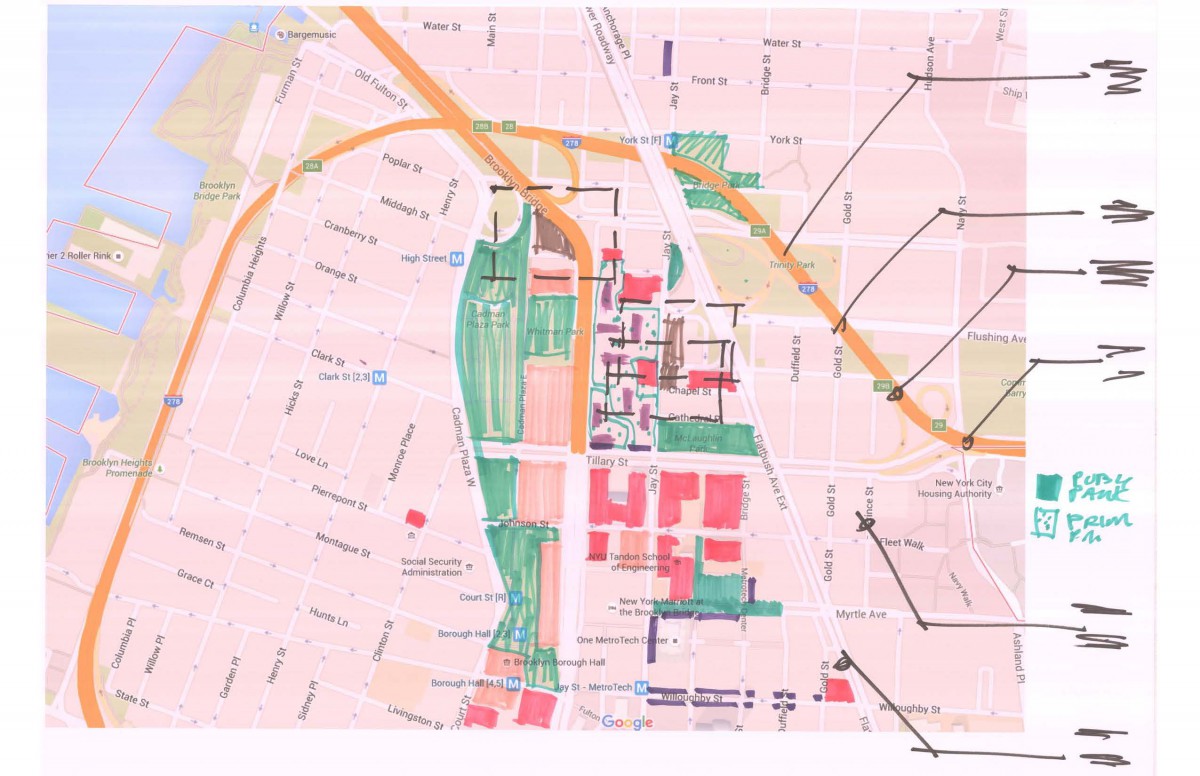
Drawings: Start by developing a base map that will accommodate all of your drawings. Most of your categories will fit on the same size site plan but some including circulation and land use might require a second large map. We often refer to this map as the Neighborhood or Environs Map. For example you should indicate significant open-spaces including Metrotech Center and Cadman Plaza as well as the subway stations in both locations. You might consider combining open-space and circulation on one larger map.
Our sheet size for our semester will be 22 x 34 full size or 11 x 17 for half size – in landscape mode. Look to format these maps to print well on an 11 x 17 printer.
Look to develop a system of graphics and labeling that is consistent for all of your maps. Labels should be large enough to read from a distance when pinned up on the wall. Some can logically be combined into maps that cover more then one category. Inventory and Analysis are typically on separate sheets but could also be combined onto one drawing if they are clear and readable.
Categories: Start by drawing each of these categories as a separate overlay. After they are done consider if you can logically combine similar categories onto a single map to limit the number of sheets you will need. Remember to work on top of the same base plan for each category, It helps to have this with you when you visit the site.
Land Use / Open-Space/ Zoning: A basic overlay of the site and adjacent buildings identifying existing building uses, existing heights and zoning categories (C6-2, etc). It is useful to understand the adjacencies to your project site. Also note the existence of any parks or open-spaces.
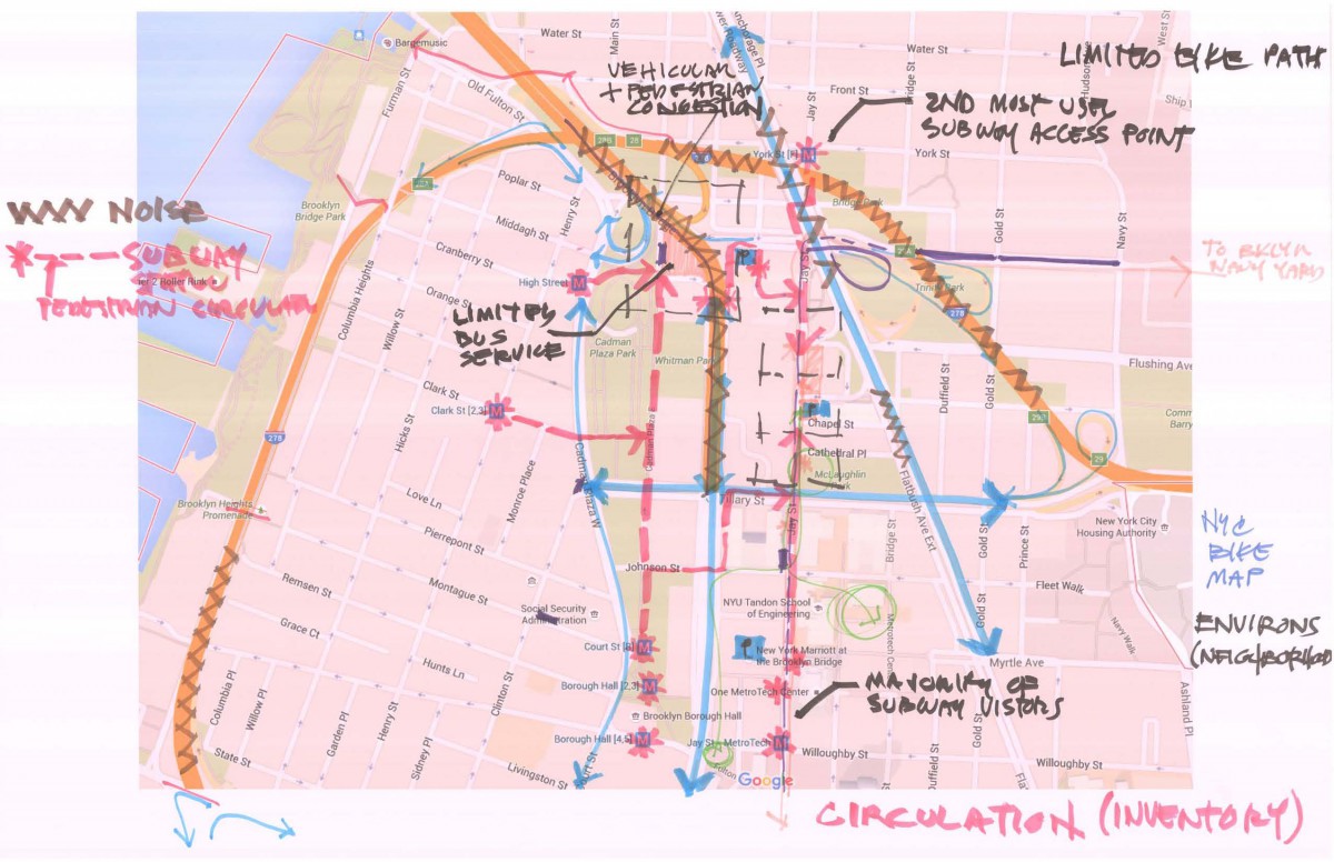
Circulation: Identify circulation close to your site – how people will get to your project site? Clarify different categories of circulation, for example Public (bus/subway) vs Private (car/private bus) and types Pedestrian, Bicycle, Vehicular.
Always look to identify the “node” or decision point- a place where people change from one mode of transit to another (exit the subway and start to walk). For example for subways and buses these are the stations or stops. For bikes these would be the bike racks or the citibike stations. For cars these would include exits from highways or the bridges and the parking lots.
Noise: Are there any significant sources of noise? Typically these exist adjacent to roadways and so we can add them to the Circulation map.
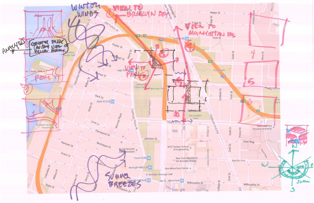
Views to and from your Site: Mark on your drawing views to your site – where is the site visible and significant views from your site. For example some of the sites have a view of the Brooklyn Bridge – this is worth taking advantage of – it will be considered an asset.
So to be clear the inventory says there is a view – the analysis says its good (an asset) and the design response is to locate a space in the building that takes advantage of the view.
Geology/Hydrology: Typically geology is important because it helps us understand the sites ability to support development. For example can it support a tall building due to bedrock or would it require piles? Does the site have a high water table or a water feature?
Typically things below grade are identified by core drilling in a grid. For most of our sites this will be difficult for us to determine so unless the features are obvious we will skip this for our sites.
Vegetation: Note the location of significant vegetation including trees, shrubs, location of parks etc. For trees it is important to note if the tree is deciduous (loses it leaves in winter) or coniferous (has needles like a pine tree that remain in winter).
For larger trees note the diameter of the trunk and if you can identify the species. Remember that these effect micro-climate.
Climate: Climate includes sun expose or diagram, winds and other factors that can create significant effect or result in a Microclimate like proximity to a large body of water. For the sun you want to show a compass (NSEW) and indicate at which angle the sun rises and sets throughout the year. For winds our prevailing Winter Winds come from the North-West and our prevailing Summer Breezes come from the South-West.
Note any locations where winds are localized and vary (Microclimate conditions). A shadow study or some indication that portions of the site are highly shaded during the day or during certain times of the year is helpful.
History: Are there any significant historical elements or building on or near the site or was the site in any way significant historically? If so we may wish to take advantage of this when we design.
School Open on Saturday
While the school is closed both Friday and Monday it will be open as normal on Saturday should you wish to come in to work.
Handout has been updated an links added
I have updated the handout that shows how to make your teammates administrators of your sites.
I have also added links and files for our zoning lesson.

