Historic maps of Greenpoint and Williamsburg

Fire insurance and other maps from the 19th and early 20th centuries offer great detail about industries and land use in this area. This 1904 map shows the extent of the American Manufacturing Company’s facilities, as well as the location of the Continental Iron Works.
View larger map

from NYPL Digital Gallery
 

The 1899 map of Greenpoint below shows how the northwest Greenpoint waterfront was dominated by timber-related industries at that time. It has been georectified upon the contemporary street grid.


View larger map

From NYPL Digital Gallery
This map, published in 1876 but based on surveys completed in 1777, shows “the original high and low grounds, salt marsh and shore lines in the city of Brooklyn.


View larger map

From NYPL Digital Gallery

Tour stops

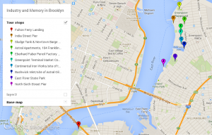
From Fulton Ferry Landing in DUMBO, we dismbark at the India Street pier and head east on India Street, turning north (left) on West Street to Eagle Street, up Franklin Street, then heading back west on Dupont Street to view the Sludge Tank and the future site of Greenpoint Landing. We return to Franklin Street and head south to #184, the Astral Apartments. We continue south on Franklin and take our third right onto Greenpoint Avenue. At the corner of Greenpoint Avenue and West Street we can observe the buildings that make up the Eberhard Faber Pencil Works and Historic District. Heading south, at the corner of West and Noble Streets we come to the site of the Greenpoint Terminal Market Complex. Heading south on West Street, we come to the site of the Continental Iron Works at the corner of Calyer. We return to Franklin and follow it south to Bushwick Inlet and the site of Astral Oil Works. We wrap up at the East River State Park, entering at Kent and N. 8th Street. [map]

  1. India Street Pier
  2. Sludge Tank/future site of Greenpoint Landing
  3. Astral Apartments
  4. Eberhard Faber Pencil Works and Historic District
  5. Greenpoint Terminal Market Complex site
  6. Continental Iron Works site
  7. Bushwick Inlet/Astral Oil Works site
  8. East River State Park
  9. North Sixth Street Pier


Greenpoint Williamsburg Waterfront Tour on Friday, September 20

Welcome back, Living Lab Fellows!  We’ll meet at Fulton Ferry Landing at 9:00 sharp on Friday, September 20. We board the East River Ferry for a 9:25 departure up the river to the India Street Pier in Greenpoint. We will be out in the field for a full 3 hours, so dress for comfort and prepare for temperatures in the high 70s, some sun, few clouds, and a breeze off the river. Directions to the ferry from campus are below:
View larger map


We wrap up by 1 pm in time to catch the 1:14 ferry back to Fulton Ferry Landing and City Tech.