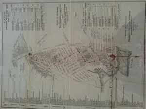
Official Map and guide of the Brooklyn elevated Railroad, 1885
Flat map B C-1885a.FI
Brooklyn Historical Society
1-What is the map’s call number?
BC-1885a.Fl
2-What is the map’s title (if available)?
official map and guide of the Brooklyn elevate reailroad
3-Which collection does the map belong to?
it belong to the fllat Map, the elevated railroad train collection.
4-When was it made?
1885
Physical description of the map:
5-What size is the map (approximately)?
11x 15 inches
6-What colors does it use?
it use red, black,and tan
7-What materials were used to make the map?
it used paper, ink to make the map
8-Who made the map?
J.W.W.Mitchell made the map
Map content:
9-What location does the map depict?
it depicts Downtown Brooklyn,Willamsburg, Navy Yard…
10-What details does it include?
it include the east river, the name of each street, train stops, time table.
11-What time period does the map depict? Is this the same as the time when it was made?
it depicts late 19th century Brooklyn railroad, and it does reflect the time when it was made.
12-What is familiar to you about the location depicted in the map?
Some of the streets like Fulton street, Jay street and the east river are familiar .
Interpretation and Reflection:
13-What is the purpose of the map?
It is a guide to Brooklyn elevated railroad.
14-Why did it survive prior to becoming part of the archives at BHS?
it survives prior to becoming part of the archives at BHS because it was an important map of its time. it shows the transportation at that time of period.
15-Why did BHS incorporate it into its collections?
because it include a lot of details, show the downtown Brooklyn and its elevated railroad in the past, it is a very important history that people study history should know; and is in good condition.
16-What is familiar or unfamiliar about the map?
some of the train stops are still here today, it is familiar, but some streets like Pearl Street are changed, the structures are not the same as in the 19th century.
17-What additional information would you want to better understand the map?
I want to know what is the time table? why it is on the map
18-Where is City Tech in relation to this map?
it is on the western part of the map.


