
Site Analysis Due Sep 14, 2022- Group
Site Strategy Diagram Due: Sep 21st 2022- Individual

ARCH 3512 Site Analysis- The New York State Pavilion

Site Analysis - Parks Department
ASSIGNMENT: Site Documentation….then Analysis
Site Analysis discussion. Site Visit.
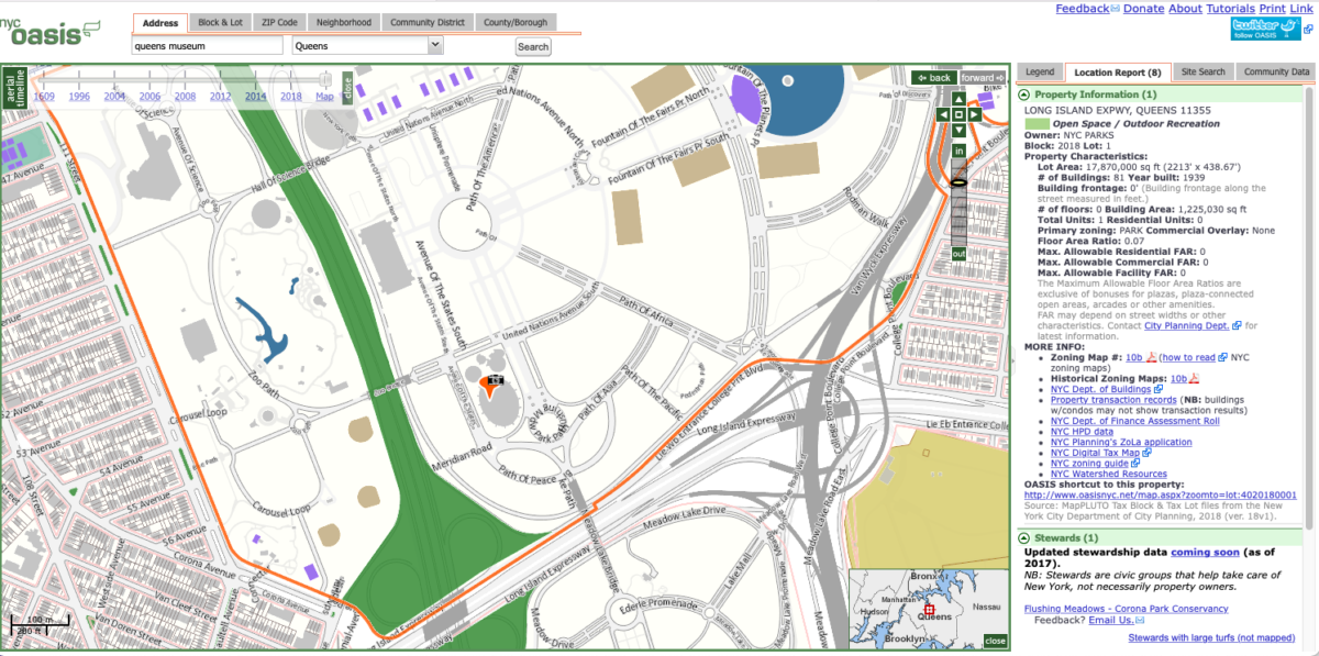
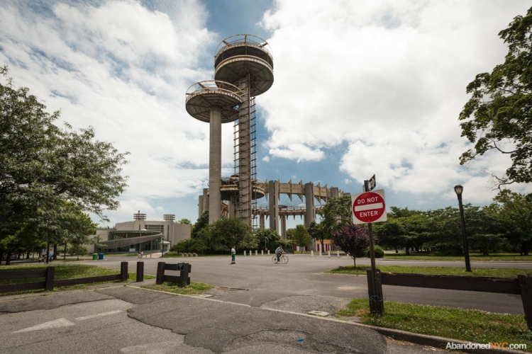
Site is located on Flushing Meadows–Corona Park in Flushing, Queens.
New York State Pavilion, Queens, NY 11368, United States
https://www.nycgovparks.org/parks/flushing-meadows-corona-park
https://www.archdaily.com/492148/ad-classics-new-york-state-pavillion-phillip-johnson
Site analysis is an integral and necessary step in the design process that involves research and understanding of a specific site and its environment.
The process is essential to understand design opportunities and challenges at both the urban and building scales.
The process involves Site Documentation and Site analysis.
More than just one element goes into a given site analysis. These elements include location, neighborhood context, site and zoning, legal elements, natural physical features, man-made features, circulation, utilities, sensory, human and cultural, and climate components.
Objective
Students will analyze social patterns, behaviors, flows, and narratives specific to our site
Initially, student groups will form to collaborate and document site-specific characteristics.
Structure
The studio will work in four groups.
Each group will collectively generate the following documentation:
Site Documentation: To develop drawings documenting existing conditions that serve as a basis for contextual analysis and architectural design work
Site Analysis: To develop a clear understanding of contextual forces in society and within the built environment that inform architectural and urban design strategies.
Document your site by gathering photos and visiting the site and taking your own photos. Make sure you show a map and a site analysis as to why this is an ideal location for your clients.
Create one base map that the entire group can use to document the following:
Answer the following:
SITE: Location- The site should be related to major streets or landmarks previously existing. Aerial photographs help in this assessment stage. There should be documentation of distances and time from major places.
SITE: History includes neighborhood history, timeline, images, text
SITE: Generalities-LAND USE Includes, figure ground, commercial vs residential, industrial, greenspace etc
SITE: Commerce Includes but not limited to hotels, restaurants ,grocery stores, cafes, bars, places of interaction, schools, places of worship, community centers, etc.
SITE: Legal Elements Includes zoning classifications, FAR, set-backs, height restrictions, allowable site coverage, uses, and parking requirements , landmark and flood zone requirements.
SITE: Circulation/Pathways Includes Residential to Commercial, Residential to Residential, Subways to Residential & Commercial, bike paths, walking distance – 5,10,15 min radius, Schools to Commercial, etc.
SITE: Climate and Natural Light Includes natural light intensity, natural light density, analysis over time/space, flood zones, etc.
SITE: Demographics Includes race, income, ethnicity, national origin, building cost, etc.
SITE: Urban Fabric Includes façade patterning, materials, hierarchies, solid/void, rhythm, repetition, etc.
SITE: Views from the site. Frame the views that occur from your site.
INDIVIDUAL ASSIGNMENT after completion of Site Analysis
SITE STRATEGY DIAGRAM: Collage of your major impacts to the site. This is one sheet that highlights the most influential elements that were found in your site analysis. This site diagram will guide you in making decisions in your design process. It is a summary of what you found during the site analysis.
HOMEWORK: Site Analysis along with a class site model.
Sources
Sanborn Maps
Google Earth
USGS surveys
U.S. Census
Field Study
Visit and document site-specific information related to your chosen area of expertise. Your field study should extend beyond into the greater neighborhood vicinity. Using a camera, measured sketches, mapped documentation, and other devices–record what you see.
Your documentation may include:
street widths, sidewalk widths, building dimensions, façade elevations, site context sketches, site sections, etc.
Requirements
Student groups will generate precise base drawings of the following:
context plan, site plan, site sections, site elevations, massing diagrams, etc.
Produce four (minimum) analytical site mappings/diagrams.
Your documentation may include various themes, depending on your area of focus, including demographics, architectural context, sectional qualities, density, accessibility, site lines, places of egress/entry, transportation links, subway locations, movement and flows of the site, paths, circulation, lighting conditions, etc.

