https://openlab.citytech.cuny.edu/groups/the-gowanus-project-libarch2205-fa2017/
Gowanus Project Site
Leave a reply
https://openlab.citytech.cuny.edu/groups/the-gowanus-project-libarch2205-fa2017/
We will conduct 1 last library/ archive visit next Tuesday, November 14th.
We’ll meet at the site at 10:45 SHARP. We’ll spend an hour or so at the archive and will break by noon in case anyone wants to photograph Gowanus or walk down to the canal before returning to campus.
Interference Archive is located on:
314 7TH STREET (BTWN 4th & 5th Avenue)
BROOKLYN, NY 11215
Best public transit option is the F/G/R train to 4th & 9th. The B63 bus also runs down 5th avenue from Downtown Brooklyn.
Text / Call with questions: 401-580-3423
Hi All,
Carmen, the NYPL librarian we worked with today, shared a list of the materials we looked at, which may be helpful for your site reports:
• Insurance maps of the borough of Brooklyn, city of New York [1912-1942]
Vol. 6, updated to 1977,
o Map Div. (Sanborn Map Co. Insurance maps of N.Y.) Offsite
• Robinson’s atlas of the city of Brooklyn, New York : embracing all territory within its corporate limits; from official records … [1886] plate 29.
o Map Div. (Brooklyn) (Robinson, E. Robinson’s atlas of the city of Brooklyn) (Disbound)
• Plan for the drainage of that part of the city of Brooklyn which empties its water into Gowanus Creek & Bay, 1848
o Map Div. 01-1886 [Filed with Brooklyn. Related work in Map Div. 01-1887]
• Plan of the city of Brooklyn, L.I. 1855, plate 9
o Map Div. 87-5624 in 15 sheets – only need sheets with Gowanus Canal
• Downtown Brooklyn, Fort Greene, Clinton Hill. (cont.) v. 3 1969
o Map Div. 80-680
• Use District Map Section No. 16
o Map Div.+++ 00-13147
• Plan of the city of New York in North America : surveyed in the years 1766 & 1767
o Map Div. 01-314
• Brooklyn–Dumbo, Ft. Greene, Downtown, Park Slope, Red Hook, Clinton Hill, Williamsburg, Gowanus, Bk. Hts., Astoria & Long Island City-Qns. : the essential guide to neighborhoods, restaurants … for urban explorers / Red Maps ; RedMaps.
o Map Div. 16-4530
• Gowanus improvement.
o IXZ p.v. 381 no. 1-6
• Sanborn Brooklyn v. 1, v. 6 updated to 1972
o Map Div +++ 02-423 (Book)
• Rediscovery Map of Brooklyn 1979
o Map Div 82-3023
• Hagstrom Brooklyn 1985
o Map Div 86-4004
• Brooklyn Waterfront Greenway 2009
o Map Div 14-1224
Here are also links to digital redlining maps and Gowanus digital collections at NYPL: Redlining Maps | Digital Collections : Gowanus
See you all on Thursday.
N.A.
As a reminder, we will meet on Tuesday 10/24 at the NYPL Schwarzman Building (D/B/F/M Trains to Bryant Park or 4/5/6/7 trains to Grand Central) at 11am (please arrive a few minutes early–I will be at the library by 10:45) outside of the Map Division (room 117).
Here’s the location information:
https://www.nypl.org/locations/schwarzman
If you get turned around, or are late, please text me so I can meet you and direct you to the classroom: 401-580-3423.
I’m meeting the librarian tomorrow (Friday 10/20) who is pulling materials for us at 12pm in this same location. If anyone wants to join me, please give me a call and let me know to expect you.
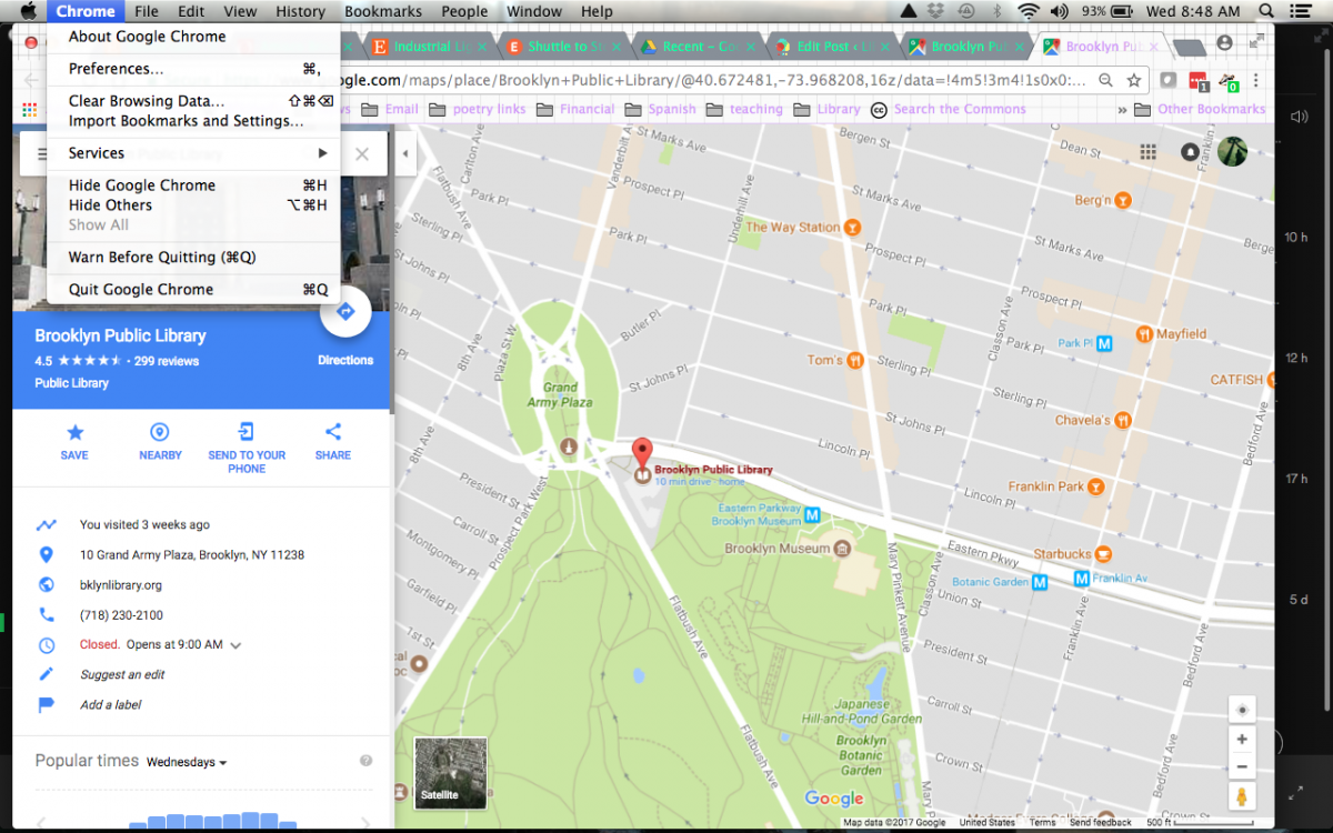
On Thursday October 5th we will visit the Brooklyn Public Library (Central Branch) and look at materials in the Brooklyn Collection (2nd floor).
Meet in front of the library at 10:40am sharp. The library session will start at 10:45 and we will be meeting in a non-public area. If you are late, go up to the 2nd floor of the library and TEXT (don’t call) for entry: 401-580-3423.
The Brooklyn Public Library is located at Grand Army Plaza and is accessible from the 2/3 trains to Grand Army Plaza, the Q/B trains to 7th avenue, or the B41 bus that runs up Flatbush. If you are coming by car, be aware that this is a very difficult neighborhood for parking.
The OpenLab is an open-source, digital platform designed to support teaching and learning at City Tech (New York City College of Technology), and to promote student and faculty engagement in the intellectual and social life of the college community.

