Site Grading

Site Grading Techniques
Analyze existing conditions of the site:
路 general flow of water
路 existing flow lines for surface runoff
路 existing structures, trees, etc. to be saved
Set preliminary elevations of structures:
路 analyze existing elevations of structures
路 check elevations with adjacent elements
路 check relationships between buildings, walks, parking lots, etc.
Modify appropriate contours:
路 begin from known points and calculate slope to next contour
路 work each contour line completely to be sure to meet to existing
路 calculate required slopes and modify all other contours as necessary
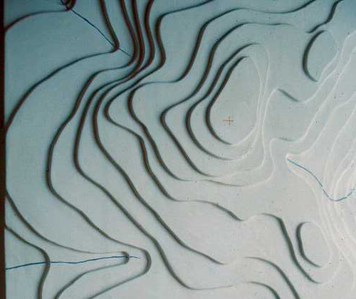
Grading Tips
路 Water always flows perpendicular to contours.
路 Closely spaced contours = steep slopes / widely spaced contours = a gentle slope.
路 A contour which closes on plan indicates a peak or a depression.
路 Contours should never cross each other
路 Always slope ground away from structures.
路 Grading must not extend beyond property lines.
路 Start grading slopes at the top of a fill slope and the bottom of a cut slope.
路 Contours at curbs point downhill.

Posted in Uncategorized | Leave a comment

Land Use and Zoning information

You can find Zoning and Land Use information about any site located within the NYC boundaries through a software called ZoLa.

The link below is directly to the Stuyvesant Square Park site. You can turn on and off different kinds of information (layers) through the menu on the right and read specific information using the “i” button on top.

http://gis.nyc.gov/doitt/nycitymap/template?z=8&p=988628,206598&a=ZOLA&c=ZOLA

Posted in Uncategorized | Leave a comment

Vignette #3: Contour model

This is an example of a simple contour model which is very similar to the one you have to create.

In addition to building the contours, you have to select a favorable location for a building site and plan for an access road to the selected site. Create a legend or/and a color code to identify the compass directions, different land forms, direction of water flow, bodies of water, building site, road and any other site features.

If you send me photos of your progress, I can comment and help you with the assignment.聽 Please let me know if you have any question regarding the vignette.


Posted in Uncategorized | Leave a comment

How does climate affect building type, size and orientation?

Cold climate zone has very long cold winters, strong winds and deep snow

Site planning strategies in the cold climate zone would include:

  1. control winds
  2. maximize the use of the winter sun
  3. group activities to minimize outdoor travel
  4. use compact building forms to minimize exterior surface
  5. use ground as shelter

Cool-temperate climate zone is the largest climate zone. It has warm and hot summer, cool and cold winters and moderate spring and fall.

Site planning strategies in the cool-temperate climate zone would include:

  1. block cold winter winds while admitting cool summer breezes
  2. maximize shade in the summer
  3. maximize southern exposure for capturing the winter sun
  4. consider extreme conditions such as high wind speeds, flooding and snow
  5. use multistory structures to minimize summer heat gain and winter heat loss through exterior surfaces

Hot-Dry climate zone has clear skies, dry air, long periods of overheating and large daily temperature variations. Days are hot, nights are cold, rainfall is minimal and vegetation is sparse.

Site planning strategies in the hot-dry climate zone would include:

  1. shading and screening to provide relief from the heat and glare of the sun
  2. use thick walls for thermal mass
  3. utilize a courtyard which provides shade and shelter
  4. preserves natural plant materials
  5. use compact plants that require little irrigation and help increase humidity levels
  6. maximizes humidity through pools and fountains
  7. maximize and utilize summer air movement

Warm-Humid climate zone has high, relatively constant temperatures and humidity, variable winds with occasionally hurricane force and torrential rains.

Site planning strategies in the warm-humid climate zone would include:

  1. provide shade and maximize air movement
  2. use narrow floor plan for better cross ventilation
  3. use high ceilings for air circulation
  4. protect against heavy rains, flooding and strong winds
  5. protect building interior from direct sun exposure

Posted in Uncategorized | Leave a comment

Photovoltaics

Photovoltaics (also called PV) is a method of generating electrical power by converting solar radiation into electricity. The system consists of photovoltaic panels, DC-AC power inverter, battery bank, system and battery controller, auxiliary energy sources. See an image below for the links between the different components.


For the purposes of your vignette you have to locate only the photovoltaic modules/panels. The other system elements will be located somewhere inside the building and are not a concern.

The image below shows one way of positioning photovoltaic solar panels on the roof of a building.


Posted in Technology | Leave a comment

Solar water heating panels

This a picture of 2 flat solar water heating panels. You have to locate equipment similar to this one on your building section. Your storage water tank can be located in the building and its exact position is not a concern.

Posted in Technology | Leave a comment

Solar+Geothermal

There was and interesting question in class yesterday – if we can combine solar and geothermal energy to achieve maximum efficiency throughout the whole year. I found information about a product that can do exactly that. Please see the link below for the video describing the product and the system operation during different seasons.

http://www.immosolar.com/en/systems-a-products/video

Posted in Technology | Leave a comment

Geothermal energy

https://www.youtube.com/watch?v=NiNPhFqxODU&feature=related

https://www.youtube.com/watch?v=e1r7fXO0QII&feature=related

These are two videos that explain the principles of geothermal energy application in building heating and cooling. As you will find out from one the videos, this energy source can be applied for any building type and in different climatic zones, therefore it is an extremely powerful way for receiving energy.

Posted in Technology | Leave a comment

Sun path chart creator

It is important to understand a sun chart and be able to read the information from it because sun charts can be easily generated for any location on the Earth surface. This is an invaluable tool when designing a structure, especially when someone can not observe the site directly

There are websites and programs that provide sun path information and also generate sun charts. Here is link to such a website:

http://solardat.uoregon.edu/SunChartProgram.html


Posted in General topics | Leave a comment