On my first report on this research article “Iterative Hyperspectral Image Classification Using Spectral-Spatial Relational Features” conducted by Piertro Guccione, Luigi Mascolo, and Annalisa Appice we discuss many things involving remote sensing images. The research was conducted on an algorithm that classifies hyperspectral remote sensing images. They compare the algorithm with an algorithm of spectral-spatial classification. The algorithm is based on the ideas using two classifiers that work together and using relational features based on spatial structure.

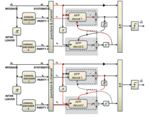
Figure 1: High-level scheme of turbo code encoder and decoder used for classifying hyperspectral images.
Figure 1 shows us a diagram of what they are researching. They took a small sample size and convoluted it with a random but related bit and then classified. We then calculate if the posterior probability satisfies the following equation: 
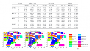
The experiment consisted of taking different spectral images and placing the pixel in the encoder and decoder system. In the Indian Pines and Salinas with an AVIRIS sensor, Pavia University with the ROSIS sensor and got the following resuls comparing the OA (overall accuracy) , AA (average accuracy) and k-statistcal results.
The results show that the algorithms are not that bad and quite accurate thus showing that using the algorithm shown can be used for image classification with spectral-spatial relational features.


