We chose to research the development of an information resource, we are proposing a mobile application which will allow commuters to view current train locations and platform conditions within the New York City subway system, as well as tools for locating stations, planning trips, and receiving alerts from the MTA. Access to real-time train data would be valuable to commuters in several ways. They would be better able to manage their transit time, identify train delays before entering the system, and make alternate transportation plans when problems arise. Studies have also shown that “mobile access to real-time bus arrival information decreases the perceived and actual wait times for riders” (Rojas, 14). Accurate information on train positions would also be useful for emergency workers in situations where trains have stopped in between stations. Finally, advocacy groups could use the data to get a clearer picture of how efficiently the subway system is operating.
Our sources included:
- Websites for existing mobile applications that present New York City subway information (Railbandit, KickMap, Exit Strategy, etc.).
- A New York Times article on an app development contest sponsored by the MTA earlier this year.
- A Flash simulation of subway train movements over the course of a normal weekday derived from published schedule information.
- A Google Group run by the New York MTA where web developers are discussing the implementation of an open data feed of train arrival and departure information.
- News items about SubwayArrival, an iPhone app that aggregates data from user’s phones in order to estimate subway car movements.
- A research paper published by The Transparency Policy Project which examines the ways that various metropolitan transit agencies have shared their operations data with the public and how developers have utilized this data.
- San Francisco Municipal Railway’s “Live ‘Snapshots’ of Muni Subway” web page.
- EarthCam’s live camera feed from Times Square.
When we began work on this project, we started with a very broad idea of an application that would make use of all the open data that the New York City government makes available for public use. As we looked at all the data out there, we realized we needed to narrow the scope of our research and decided to focus our application on information about the New York City subway system. A feature which we thought would be useful but has so far not been effectively implemented by existing applications is the ability for commuters to access information on the current state of trains on a given line and to find out how crowded your chosen station platform is. Further research revealed that the MTA is currently developing an open data feed of train schedule updates that can be used by web developers for just this sort of application. This data is still a little short of being truly “real-time,” since it only provides a revised estimate of the arrival and departure times for a given train 30 minutes before the train’s scheduled arrival. Actual real-time train position data would require the implementation of additional sensing technology within the subway system.
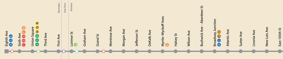
The application would first present the user with the standard MTA map of the entire New York City subway system (fig. 1). From there, the user could then select a subway line or specific station and be presented with a linear representation of all the stations on the line (similar to the maps that are featured in modern subway cars) (fig 2). The user can pan along and zoom into the map to the station(s) that they are interested in. Available connections to other train lines would be listed under the station name. Markers representing trains would be displayed along the line indicating their current position, updating automatically every thirty seconds. With the schedule update feed currently being implemented by the MTA, current train position between stations could be estimated from the departure and arrival times received from the feed. If positioning sensors were installed, actual train position could be displayed. Alerts from the MTA regarding delays and changes in service could also be displayed in pop-up windows. An interesting possibility would be the ability to open a live camera feed from a given station platform in order to see how crowded the platform currently is (fig 3). This would require making feeds from the MTA’s security cameras publicly available, which would likely raise security and privacy concerns and therefore be difficult to implement. Another possible feature would be a feedback window where commuters could evaluate their transit experiences.

